I am fascinated with the history of the roads and trails of my place, especially the old ones. This 1914 automotive touring article describes a trip along some relatively old roads; East 14th & Foothill Boulevards are basically the old Camino Real, or Mission road from the time of the Spanish missions. The road he describes from Hayward is the old Redwood Road, used to bring lumber to the wharves of Castro Valley from the various mills in Redwood Canyon, and the Moraga road descent to Piedmont Avenue return is also a very old redwood logging road.
 |
| From Redwoods Atop Oakland Hills First Brought Settlers Here - Oakland Tribune - 09 Oct 1966, Sun - Page 137 |

|
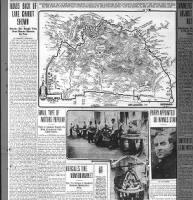
| AUTOMOBILE ROAD MAP OF THE HAYWARD-REDWOOD CANYON AUTO TOUR AS COMPILED BY THE AUTOMOBILE DEPARTMENT OF THE TRIBUNE FROM THE DATA SECURED FROM THE SPEEDOMETER OF A BUICK CAR DRIVEN OVER THE ROUTE THIS WEEK BY FRANK SANFORD OF THE HOWARD AUTOMOBILE COMPANY FOR THE PURPOSE OF SUPPLYING THIS DATA FOR THE READERS OF TODAY'S OUTING SECTION. SAVE THIS SECTION, AS THE MAP WILL NOT APPEAR AGAIN. |
ROADS BACK OF LAKE CHABOT SHOWN
Scenic, But Rough Trip Over Routes Known by Few
(By EDMUND CRINNION.)
More with the idea of settling the question as to where the road leads to than with the purpose of recommending it to travel the automobile department of THE TRIBUNE presents today a map of the Hayward- Redwood canyon auto tour as compiled from the data secured this week from the speedometer of a Buick car driven by Frank Sanford of the Howard Automobile Company, who made the trip for the purpose of securing this information for the readers of the Sunday TRIBUNE Outing Section.
The automobile department of THE TRIBUNE has received more queries as to where the road that crosses the Castro valley cut-off leads to than has fallen to the lot of any other road or tour in this section of the state. It is for that reason that the accompanying map was compiled and is published today. This road, starting from Hayward, cuts across the Castro valley cut-off and winds in and around about San Leandro creek in the hills back of Lake Chabot, finally connecting with the Redwood canyon road and back through the Redwood canyon to Oakland by way of the Moraga road back of Piedmont. From a scenic standpoint it is well worth while. But the conditions of the road for some eight or nine miles make it far from popular. We do not recommend it, especially as there are so many really pleasant drives leading to the Redwood canyon available, most of which have been shown on previous maps in the outing section. This road is both rough and extremely dusty for about nine miles, the balance of the trip is over good highways.
To make the trip along the route followed by the Buick car set the trip indicator of your speedometer at naught on leaving the city hall. Follow out 14th st., dropping down to 12th st. at the lake, follow E. 12th st. to 1.7, turning to L on 13th ave.; 1.8 to R on E. 14th st.; 2.7 to L on 24th ave.: 2.8 to R on Foothill boulevard; 10 at Estudillo ave. str ahead; 10.2 at Maud ave. to R; 11 in San Leandro to L on E. 14th; 14.5 str ahead; 14.7 str ahead (Castro valley cut-off on L); 16 in Hayward to L up over A st.; 16.2 str ahead, passing Boulevard intersection; 16.6 bridge; 16.7 str ahead; 16.8 to R hand fork; 17. str ahead (Dublin canyon road on your R); 17.4 str ahead; 17:8 str ahead, passing Castro valley cut-off road; 18.6 str ahead; 18.8 str ahead (short cut to Chabot road on the L); 19.2 str ahead; 20.7 to R hand fork; 23.3 to L hand fork, crossing small bridge; 23.7 str ahead and bear to R; 24.5 str ahead; 25.2 pass schoolhouse and turn sharp to R (road str ahead leads back to the "Hights," over road as rough and dusty as the one you have been following); 25.8 str ahead (road on R to High Oaks and Kelley Bros.' ranch); 27.6 str ahead; 28 str ahead; 28.3 str ahead on L hand fork; 29.6 sharp to L (road to R to Moraga, Tunnel road, Lafayette and Orinda Park); 30.2 str ahead; 30.4 to R over R. R. bridge; 32.3 at Redwood Inn; 33.4 to R under R. R. trestle; 33.7 sharp to L up over hill (road str ahead to Thornhill grade - steep and very dangerous); 35.1 break up over first summit; 36 str ahead, bearing sharp to L (road connecting from the R from the Thornhill grade); 37.5 make loop and cross under R. R. trestle; 37.7 bear sharp to the R across meadows to Moraga road; 37.8 Moraga road to R (those preferring to return to Oakland through the Fourth ave. district will turn to L here); 38.4 str ahead, passing Thornhill road intersection on your R; 38.8 str ahead, bearing to the L (road on the L leads up past the Claremont Country Club); 39.1 str ahead on lower road; 39.6 pass Highland ave. in Piedmont; keep str ahead following on down through Piedmont, reaching Piedmont ave. at 40.5; 41.5 str ahead down, Broadway at Piedmont ave. intersection; 42.9 arrive back to city hall in Oakland, still debating just what to do to get even with THE TRIBUNE automobile editor for having sent you over that stretch of road between the Castro valley cut-off and the Redwood canyon road. But remember, friends, we do not build these roads, our work is to map them and tell you whether they are good or not - this one is not.
If you've made it this far, thanks. Here's where I'll point out some interesting details. First, the hand-drawn map doesn't actually represent the roads as they existed. It's conceptual. I've used a GIS tool, QGIS to map out the mileage numbers, and figured out what he's talking about. Here it is, with the bold lines representing the route he drove drawn red, and the thinner lines, representing alternate routes drawn blue, overlaid on 1915 USGS topographical maps, showing the roads as they were, then:

|
|
300dpi, zoom-able and download-able version
here |
Here are the same roads overlaid on the base OpenStreetMap, representing the modern world:

|
| 300dpi, zoom-able and download-able version here |
I couldn't resist overlaying it on this 1914 "Alameda County, California." map by J. J. Rhea. It's beautiful.

If you want the QGIS project file I'm using, let me know in a comment.
Some details:
-
It's fascinating that in 1914, ~65 years after these roads were created to transport the huge redwood logs to their eventual destination, this Oaklander knew so little about them. We know more about them, now. Thanks, internet.
- The "Castro Valley cut-off road" is now Mattox Road / Castro Valley Boulevard
- 4th Ave was later renamed Park Boulevard
- He mentioned "road on R to High Oaks and Kelley Bros.' ranch." I have been unable to figure out what either were, but the road he's talking about goes up Kaiser Creek, where there are multiple structures represented on the 1915 USGS map.

- The "ROCK QUARRY" is now where Corpus Christi School is, on Park Boulevard.

- He shows a triangle of roads near "The Hights." The lower leg of that triangle is hinted at by some dashed lines that disappear on the 1915 USGS topo maps, suggesting that Jordan Drive on the south and Burdeck Drive on the north might have met somewhere in the Peralta Creek drainage. By 1936 Mountain Boulevard connected them.


- This line gets me: "37.7 bear sharp to the R across meadows to Moraga road; 37.8 Moraga road to R (those preferring to return to Oakland through the Fourth ave. district will turn to L here);" It's where he's finished descending what's now Snake Road in Montclair, and he's reached the road that lies along the Hayward Fault, where Highway 13 is now. He turns right to get to Moraga Avenue - the road that is named for its destination, from the perspective of Oakland - but he's suggesting you might turn left to go down what's now Park Boulevard. But... it was a meadow and a dirt road. Fascinating to think about.
- Look closely at the image, below. He's not driving a boat. San Leandro Reservoir was created by damming and flooding San Leandro Creek in 1926, 12 years after this article was created. I will share more stories about that. He writes "25.2 pass schoolhouse and turn sharp to R" That schoolhouse was in the tiny village of Redwood, at the confluence of the San Leandro and Redwood Creeks, it was removed to a new location - now within the Aurelia Reinhardt Redwood Regional Park I believe - before the valley was flooded. The school closed in 1964. I have traveled the route he describes, but offset from his actual route, above the waterline, from Rancho Laguna Park in Moraga to the Chabot Staging Area in Castro Valley. It's beautiful.

- The blue line in the image below is the old Redwood Road, now called Redwood Road, but the modern version is aligned higher up on the west side of the valley - due to the flooding of the valley. You can still see the remnant of the old alignment, blocked by an EBRPD gate before it dives underwater. He refers to this road, when turning right at the school; "road str ahead leads back to the "Hights," over road as rough and dusty as the one you have been following." This image, below shows the old Redwood Road alignment, and the new Redwood Road alignment, where they diverge and continue. The modern Redwood Road is currently closed, due to massive landslides.


-
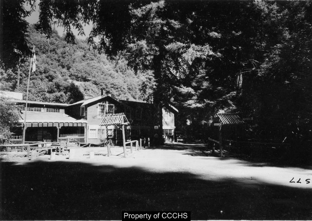
What was the Redwood Inn, on what's now Pinehurst like? Here's a photo, from the
Contra Costa Historical Society
|
|
Description: Canyon Store; 9-17-37 Also 'Redwood Inn' |
-
You can read about
Hiram Thorn
and
Thornhill
plenty on this blog. Crimmion writes "road str ahead to Thornhill grade -
steep and very dangerous." It's now Thornhill Drive / Sobrante Road /
(nothing) / Lower Huckleberry Loop Trail / Lower Pinehurst trail /
Pinehurst, when imagining southwest to northeast.

-
Skyline Boulevard wasn't yet built. The segment of road up Redwood Canyon, what's now Pinehurst Road to "35.1 break up over first summit" to what's now Snake Road is unnamed in this telling. It's now part of Skyline Boulevard, which was built in the next year, 1915, completed as we know it in 1925. The dashed line, on the south end of what's now Skyline is remnants of the old "McNally road." More to come on that.

- Similarly, the section of Pinehurst Road didn't yet exist, between Redwood Road and Canyon Road, where modern Pinehurst continues up the Redwood Canyon. Look closely at the underlying yellow road, showing modern Pinehurst, and the curious, dashed road line that shows what existed in 1914, bridging the two canyons across the divide. The modern section of Pinehurst between Redwood Road and Redwood Canyon was built in 1927. "Pinehurst" was originally a stop on the Oakland, Antioch & Eastern Rail Road, a picnic grounds.


- If you click Edmund Crinnion's name above, you'll see he died in the 1918 influenza epidemic. He was born in 1884.
- Charles S. Howard, owner of the Howard Automobile Company was also famously the owner of the race horse Seabiscuit.
- What's the difference between Redwood Canyon and Little Redwood Canyon? They are often confused. When he wrote this, Little Redwood Canyon was the drainage containing Redwood Creek, which is now AKA Aurelia Reinhardt Redwood Regional Park, and Redwood Canyon was the drainage containing San Leandro Creek, now AKA Pinehurst road, where the town of Canyon is. This article, The Hiker's Paradise by Louis Allen - Oakland Tribune 07 May 1922, Sun Page 77 manages to disambiguate between the two.
No comments:
Post a Comment