The San Leandro Triangle
If you start to read about cycling during the 1880 - 1910 era in the Bay Area, you quickly come across many mentions of the "San Leandro Triangle". There are 161 results for it in the California Digital Newspaper Collection, 392 results at newspapers.com and google returns 477. It was a common course, I think because it was relatively flat - these bikes had no gears, and the racers were really fascinated with speed and distance records - and because it was pretty country at the time, and it was accessible from rail (Fruitvale Station in Oakland, near the current BART Fruitvale Station) and boat in a nice city. (Oakland) The route to it, on the "San Leandro Road", AKA the "Haywards Road" was scenic and a nice spin for spectators. Later, motorcycle and car races were run over the course.But where was it? This part was maddening; it was in the vernacular, and people must have just known it by being there. Road names in the 1890s were completely different from now, for the region. Period accounts are inscrutable, for instance, from a report of Charles A. Kraft trying to break the "Coast record" for 20 miles: "The course ... to the power-house this side of San Leandro .... to the first junction - beyond San Leandro ... to the first turn. From Haywards to San Lorenzo ... to the tank corner ... across the railroad track ... back into San Leandro." That made not enough sense to me. I was searching and searching for this course, which is just down the hill from my house, when I reached out to my friend Joel Metz. He replied, "Gonna check some period bike maps around here looking for clues... found it!" He sent me these, scans from the California Associated Cycling Clubs Touring Guide and Road Book of 1898. This book exists in libraries, but I'd failed to find it in digital form. Of course Joel has it, and sends me these scans:
 |
| California Associated Cycling Clubs Touring Guide and Road Book of 1898, scanned by Joel Metz |
 | |
|
He also pointed me to this map, which I uploaded and placed reference points for it in georeferencer.
 |
| Official map of Alameda County, California, 1900 |
This one, from the Rumsey collection is also useful. I also placed reference points for it in georeferencer.
Here is the 25-mile course, from the above book:
TWENTY-FIVE MILES.
TRIANGLE - Starting at a point on the main County Road from Oakland to San Leandro, 153 feet South from Ward Street; thence along said County Road (over the course commonly known as the San Leandro Triangle) to Ashland Junction, to San Lorenzo Road (Tank), to Saunders Street (in San Leandro): thence through Saunders Street to main County Road, to Ashland Junction, to San Lorenzo Road (Tank), to Saunders Street (in San Leandro); thence through Saunders Street to Ashland Junction, to San Lorenzo Road (Tank) and finish at a point 88 feet South Easterly from the intersection of the Easterly line of Parrott Street in San Leandro with the center line of the San Lorenzo Road, (The finish is marked on a tree on the edge of the sidewalk on the North side of said road.)
I found this valuable page, showing which San Leandro street names had changed:
Ward St. became West Estudillo Ave.
Saunders St. became West Juana Ave.
It became apparent that:
County Road from Oakland to San Leandro = International Blvd / East 14th St. / Mission Blvd
Ashland Junction = East 14th & East Lewelling Blvd
San Lorenzo Road = Washington Ave.
I added placemarks - carefully measuring with the ruler tool - and added a 'path' in google earth to show the course:
County Road from Oakland to San Leandro = International Blvd / East 14th St. / Mission Blvd
Ashland Junction = East 14th & East Lewelling Blvd
San Lorenzo Road = Washington Ave.
I added placemarks - carefully measuring with the ruler tool - and added a 'path' in google earth to show the course:

Here is the path (course) and the place markers:
Note that there is a road-cut to soften the corner at "Ashland Junction" (Mission Bvd & E. Lewelling Blvd). They didn't have it, so go past that to the actual intersection and make the more acute turn, if you want to ride the course as they did. East 14th St changes its name to Mission Blvd after it goes under highway 238, southbound. It would have been called "Haywards Road" back then.
Best I can tell, Tank Corner is now Washington Ave & Lewelling Blvd.
I was researching the triangle itself, but if you're curious about the Damon Avenue reference in the book - the start of the 20-mile course - Damon Ave (which led to Damons Landing) became 66th Avenue, where the Oakland Coliseum is now.
- San Leandro Triangle, with 25-mile start.kmz
- Start of 25-mile San Leandro triangle course.kmz
- Ashland Junction.kmz
- Tank Corner.kmz
- San Lorenzo Road (Washington St) and Saunders Street (West Juana Ave).kmz
- Finish of 25-mile San Leandro Triangle course.kmz
Note that there is a road-cut to soften the corner at "Ashland Junction" (Mission Bvd & E. Lewelling Blvd). They didn't have it, so go past that to the actual intersection and make the more acute turn, if you want to ride the course as they did. East 14th St changes its name to Mission Blvd after it goes under highway 238, southbound. It would have been called "Haywards Road" back then.
 |
| Haywards Boulevard, Oakland, a postcard mailed in 1906 |
 |
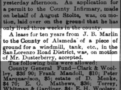
| J. B. Marlin property, from Map number three (Alameda County farm map. Published by Thompson & West, Oakland, Cala., 1878) |
I was researching the triangle itself, but if you're curious about the Damon Avenue reference in the book - the start of the 20-mile course - Damon Ave (which led to Damons Landing) became 66th Avenue, where the Oakland Coliseum is now.

I'll ride the course and add strava record, gpx file and some photos. Would be great to find some period photos and compare with "now". Unlike some of the rides back then, these roads exist intact, and can be ridden just as they rode them, with the exception that the surface material is different, and there are stop signs, stop lights and of course cars on the road! In the 1880s and 1890s, when 'cyclers' were first riding and racing on these roads, the other traffic was horse-drawn, horses and pedestrians. Some sections are not as bike friendly as they once were. It's an industrial / urban neighborhood now. My friend Jason writes: "East 14th is not bike friendly through downtown San Leandro, but it opens up after about a half mile. Washington has a stretch just before San Leandro Blvd that might pose a problem too, because it goes under the train tracks and has no shoulder."
Stories and articles I've transcribed which mention the San Leandro Triangle:
- The San Francisco Call, 25 Aug 1890, Mon, Page 7 - WHEELMEN’S WHIRLS - Entries for the Twenty-five-mile Race. Trip to Tamalpais.
- AMONG THE WHEELMEN - San Francisco Chronicle 15 Jun 1895
- THE WHEELMEN. San Francisco Call, 14 August 1897

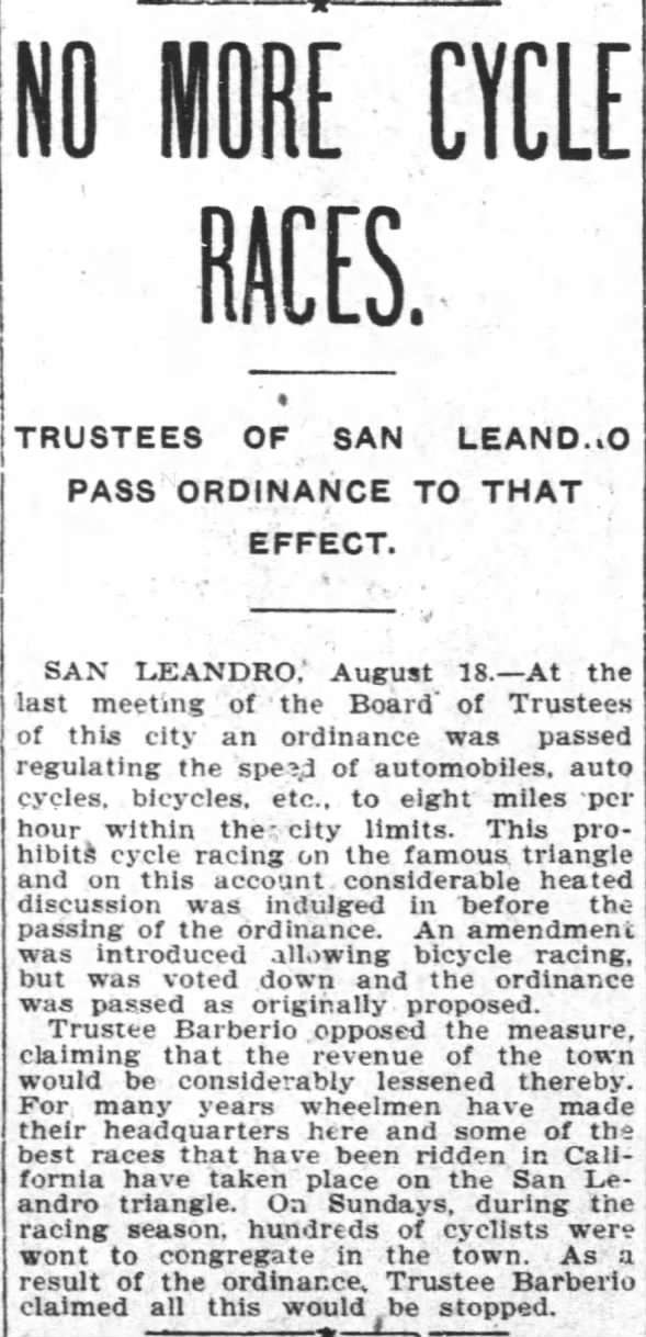 Thu, Aug 18, 1904 – Page 7 · Oakland Tribune (Oakland, Alameda, California, United States of America) · Newspapers.com
Comments
Post a Comment