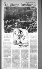
 The Hiker's Paradise
Kohler Creek
Thorn road Sun, May 7, 1922 – Page 77 · Oakland Tribune (Oakland, California) · Newspapers.com
The Hiker's Paradise
Kohler Creek
Thorn road Sun, May 7, 1922 – Page 77 · Oakland Tribune (Oakland, California) · Newspapers.com
[See also "Short Hikes for Sunday - Oakland Tribune 26 Aug 1923, Sun" - MF]
The Hiker's Paradise, by Louis Allen
Flagstaff Hill, Redwood Canyon, Thorn Road, 'The Hights,' Leona, Niles Canyon All Lure
Trip to Lake Chabot and Dimond Canyon ; Entire Trek of Fifteen Miles Reveals Marvel Scenes
Last week Mr. Allen told how Hikers should dress and equip themselves. Today he tells about some more favorite hikes in the Eastbay.AN attractive short trip may be made, starting from the Claremont Hotel, walking a a short distance up Claremont creek road until the entrance of John Garber park is reached, thence through the park and over the undulating ridge to the top of Flagstaff hill, or follow the more leisurely trail that parallels Claremont creek to the top of the divide, where the abandoned road dips over the divide into the Contra Costa country. From Flagstaff hill a surprising view of the Tunnel road, westerly approach, is unfolded, the automobiles moving like infinitesimal insects on the white ribbon of highway far below.
[Flag Staff Hill seems to be about where the radio tower for KPFA is. - MF]
One of the finest pine forests in the Contra Costa hills is traversed on the way to Flagstaff hill. Although the trees are not tall, they are thickly studded and their interlocking fronds make of the gentle slope an ideal picnic ground. For those less harassed by the need of food, the grove may carry much the same sacred, undefinable air such as we sense when entering a great cathedral, but with this difference - Nature's cathedrals are redolent of growing things, never musty or suggestive of the past.
VANDALS IN HIGH PLACES.
If the trip is made paralleling the Claremont creek road, the view from the summit of the divide is of the opposite side of the Tunnel road, that which passes down the eastern slope toward Lafayette. If the hiker is doubtful as to the location of the summit or divide the need only observe the quaint old boundary mark between Contra Costa and Alameda counties by the side of the now abandoned road. The marker was put up in 1895 and is faced with sheet iron, but the mischievous vandals who have plugged many of our state highway signs full of holes have even penetrated to this inspiring spot, emptying their revolvers or rifles into an inoffensive boundary post.A visit to Temescal lake is well worth while and may be made in two or three hours from the College avenue cars, following Chabot road to the lake.
From Piedmont an interesting hike may be made via Moraga road to Kohler creek road (Thorn road) to the top of the ridge where the Skyline boulevard hugs the summit. If the hiker is particularly venturesome he will continue over the divide and down the other side, coming out at Eastport, where the Sacramento Short Line enters the tunnel coming toward Oakland. Such a hike would be worth while not only for the superb country passed through, but because the hiker may at the end of the trip at Eastport take electric train back to Oakland or Berkeley.
[These maps are from https://davidrumsey.georeferencer.com/compare#291144752728 - MF]
 |
| Thorn Road became Thornhill & Sobrante, which ends before Skyline now. It used to drop down the back side, what is now the Huckleberry trail that connects to Pinehurst Road. |
 |
| The Kohler property used to abut Thorn Road, thus is likely the source for his term "Kohler creek road". The road did follow something that was once called Kohler Creek, now not on maps. |
REDWOOD CANYON LURES.
Perhaps the finest possible hike within fifteen miles of Oakland includes Redwood canyon, down which San Leandro creek tumbles, and near the head of which is Eastport. Hikers who would enjoy the full length of this canyon from East port to Pinehurst would do well to take electric train to Eastport, thence walk down the canyon parallel to the creek, passing Redwood Inn and innumerable groves of big trees on either hand. Such a hike would not require more than three or four miles' walk, but these would be miles which the hiker will never forget. |
| This 1914 geological map shows the old Thorn road descending San Leandro creek drainage, made before the train line or Eastport existed. You can see some structures as little black squares. From https://davidrumsey.georeferencer.com/compare#414027826217 |
miles in an air line from city hall, would think he was in a ravine of the Sierras or the Mendocino mountains. And yet there are hundreds of thousands of people around the bay who have never visited Redwood canyon, and probably 99 per cent of these never even heard of the canyon.
From Eastport, Round Top (1750 feet) the third highest of the Contra Costa hills, whose rounded top is perhaps the most conspicuous landmark back of Oakland as viewed from the ferries, is an easy scramble. On this interesting hill may be ascended from the point on the divide where Kohler creek road [Thorn road, which is now Thornhill - Sobrante - private property - Huckleberry - Pinehurst. - MF] crosses the Skyline boulevard, or again from the Moraga valley.
About three miles south of Round Top is Redwood peak (1608 feet), the fourth highest peak in the neighborhood, which – with Round Top, Grizzly peak and Bald peak constitute the "big four" of the Eastbay hills. While almost 150 feet lower than Round Top. Redwood peak being forest covered is more interesting to the hiker, although the view from the several summits is not as satisfactory as from the grass covered peak to the north.
"THE HIGHTS."
Redwood peak will prove of special interest to Eastbay people because of the proximity of the Joaquin Miller estate, called "The Hights," which is now a part of Oakland's fast extending park system. The hiker who plans an ascent of Redwood peak might well plan to take in the Miller place en route. For this purpose he may take a Lakeshore car to the end of the line in Dimond canyon, thence walk up the canyon to the intersection with the Skyline boulevard, turning off to the right as the many signs direct, following the county road up to "The Hights." Redwood peak is a comparatively easy climb front the Joaquin Miller home, which is near the western base of the mountain.Or the hiker may take this little jaunt which the writer essayed early in March. Leaving the Leona Heights car just above Mills college, I worked north a half mile to the Redwood road, passing Camp Hiawatha and Wanderers' Rest and coming out in Little Redwood canyon at the Hauschildt ranch; thence up the wagon road in a northerly direction for two and a half miles, striking westward into the trail that winds up over Redwood peak. On this occasion, instead of coming down the slope via the Miller estate, I bore off to the northward and emerged at a point about half way through Shepard creek canyon, thence west to Montclair, thence to Dimond canyon and electrics for home. The entire trip measured not more than twelve or thirteen miles. In this trip the only real climbing occurred on the east slope of Redwood peak coming up out of Little Redwood canyon. The view of Mt. Diablo on that day as seen through openings in the wooded hillside was worth coming hundreds of miles to see. The devil mountain has little of Alpine characteristics, but in it's lonely guard off in the east it requires no great stretch of the imagination to picture another Rainier or Shasta.
 Fri, Oct 24, 1913 – Page 7 · Oakland Tribune (Oakland, California) · Newspapers.com
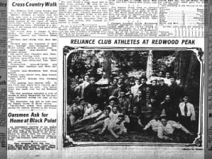 Athletes Take Cross Country Walk Tue, Aug 11, 1908 – Page 11 · Oakland Tribune (Oakland, California) · Newspapers.com
LAKE CHABOT LODESTONE.
The San Leandro hills offer innumerable jaunts for the eager hiker, but no true lover of hills and takes will long put off the trip to Lake Chabot. Take electric cars to San Leandro. The walk to the lake and along its shores is sure to be stamped one of the finest possible.Still farther south the San Leandro hills beckon with many a pretty hike over the hills into newly discovered ravines and canyons, Your true hiker sometimes forsakes trails and striking off makes his own trail whithersoever he desires. Much of the true sport of hiking lies in the venturing off the beaten path into regions never before seen by the hiker. Of course, common sense must be brought to bear under such circumstances for it is very conceivable that the over-zealous hiker may easily run into difficulties either with ranchers, "uplifting" ranch stock, or the ubiquitous ranch dog.
Niles canyon offers a veritable paradise for the hiker. Indeed, there is no limit of pleasurable jaunts in the hills within fifteen miles of Oakland's city hall, if only the hiker cares to make the effort. More hikes will be described next week.
Comments
Post a Comment