Remarkable Aeroplane Map Showing the Montclair District - Oakland Tribune - 23 Jul 1922, Sun - Page 46
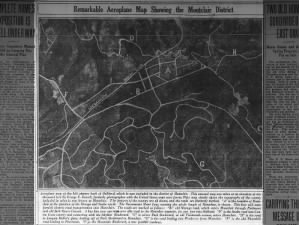 Remarkable Aeroplane Map Showing the Montclair District Sun, Jul 23, 1922 – Page 46 · Oakland Tribune (Oakland, California) · Newspapers.com
Remarkable Aeroplane Map Showing the Montclair District

Aeroplane map of the hill country back of Oakland, which is now included in the district of Montclair.
This unusual map was taken at an elevation of ten thousand feet by George E. Russell, formerly photographer with the United States army aero forces. This map clearly shows the topography of the county included in what is now known as Montclair. The features of the country are all shown, and the roads are distinctly marked. "A" is the townsite of Montclair at the junction of the Moraga and Snake roads. [Moraga becomes Mountain at that junction, now. - MF] The Sacramento Short Line, running the whole length of Montclair is shown. This line will soon furnish electric road transportation into Montclair. The roads are marked as follows: "B," old Moraga road, which enters Montclair through Piedmont and old Jack Hayes Canyon. A bus line now operates over this road to the Montclair townsite, for one fare into Oakland. "D" is the Snake road into Contra Costa county and connecting with the Skyline Boulevard. "C" is where Park Boulevard, or old Thirteenth avenue, enters Montclair. "H" is the road to Joaquin Miller's place, leading off of Park Boulevard in Montclair. "G" is the road leading into Piedmont from Montclair. [La Salle Avenue - MF] "F' is the old Thornhill road leading to Pinehaven. "I" is the Mountain Boulevard, a new foothill roadway.
Here is that map, georeferenced on a modern map:
[download link for the image above]
Some things I noticed:
I had always thought Colton Boulevard was an old road, but there is no trace of it on this map.
The area bounded by Grisborne Ave & Thornhill Drive, and to some extent opposite were developed in 1922 already.

The original "road to Joaquin Miller's place" wandered along the Hayward fault, roughly along the current Highway 13 alignment, south of what is now Mountain Boulevard but north of Monterey Boulevard. As it continued south it appeared to drop down to the Palo Seco Creek. Bear in mind that they filled in a lot of earth to make the Highway 13 roadbed, hard to know what the terrain looked like before that. It likely followed a contour. Also, look at how wavy and meandering Park Boulevard (Thirteenth Avenue) was. The grey blobs north and south of it, to the left of the photo below are the quarry at what is now the Zion Lutheran Church site.

Bruns Court, off La Salle Avenue used to connect to Mountain Boulevard at what is now the Montclair Recreation Center.

The "Sacramento Short Line" really defined early Montclair, its northern end leading to what is now Highway 13, the middle helping to define the Montclair Park, and the southern end becoming the Montclair Railroad Trail. Lucas Avenue used to run through to Snake Road. Piedmont's "Reservoir Number One" appears to have been there in 1922. What's now Fernwood Drive had an analog, but it ran to the west, likely on the other side of the creek, where the Thornhill on-ramp to Highway 13 is now. Mountain Boulevard north of Thornhill didn't exist.

Andrews Street used to run further southeast, into what's now the Village Square Shopping Center, where the restaurant Italian Colors is. I believe that was a horse ranch run by Sidney Chown. It appeared to span what's now Mountain Boulevard and Snake Road. Snake ended at what's now the intersection with Shepherd Canyon Road. Shepherd Canyon didn't exist yet. The intersections of Mountain, Scout and Park were in a sort of roundabout in what's now the empty space between Mountain, Park and Highway 13.

There was either a landslide, or a clearcut (grey triangle) from what is now Mendoza Drive and Colton Boulevard, you can see it below:

 |
| Click to embiggen |
Some things I noticed:
I had always thought Colton Boulevard was an old road, but there is no trace of it on this map.
The area bounded by Grisborne Ave & Thornhill Drive, and to some extent opposite were developed in 1922 already.

The original "road to Joaquin Miller's place" wandered along the Hayward fault, roughly along the current Highway 13 alignment, south of what is now Mountain Boulevard but north of Monterey Boulevard. As it continued south it appeared to drop down to the Palo Seco Creek. Bear in mind that they filled in a lot of earth to make the Highway 13 roadbed, hard to know what the terrain looked like before that. It likely followed a contour. Also, look at how wavy and meandering Park Boulevard (Thirteenth Avenue) was. The grey blobs north and south of it, to the left of the photo below are the quarry at what is now the Zion Lutheran Church site.

Bruns Court, off La Salle Avenue used to connect to Mountain Boulevard at what is now the Montclair Recreation Center.

The "Sacramento Short Line" really defined early Montclair, its northern end leading to what is now Highway 13, the middle helping to define the Montclair Park, and the southern end becoming the Montclair Railroad Trail. Lucas Avenue used to run through to Snake Road. Piedmont's "Reservoir Number One" appears to have been there in 1922. What's now Fernwood Drive had an analog, but it ran to the west, likely on the other side of the creek, where the Thornhill on-ramp to Highway 13 is now. Mountain Boulevard north of Thornhill didn't exist.

Andrews Street used to run further southeast, into what's now the Village Square Shopping Center, where the restaurant Italian Colors is. I believe that was a horse ranch run by Sidney Chown. It appeared to span what's now Mountain Boulevard and Snake Road. Snake ended at what's now the intersection with Shepherd Canyon Road. Shepherd Canyon didn't exist yet. The intersections of Mountain, Scout and Park were in a sort of roundabout in what's now the empty space between Mountain, Park and Highway 13.

There was either a landslide, or a clearcut (grey triangle) from what is now Mendoza Drive and Colton Boulevard, you can see it below:

A Mr. Bruns had a home on Moraga right where Bruns Street use meet it. Sidney Chown did have his home and horse stables where Montclair East is now. You can almost see it in some of the photos on the East Bay Hills Project.
ReplyDeleteOh just in case you don't recognize Littledots. I am Dorothy Londagin in the real world.
DeleteThanks, Dorothy!
Delete