"THE GLORY OF THE HILLS."
NATURE'S VARIED WONDERS BUT A SHORT JOURNEY AFOOT FROM ALAMEDA
Almost At Our Doors Are Picturesque Hills and Peaks, With Fern Grown Canyons Between.
A prominent peak in any range of hills or mountains commands attention the world over; and it is therefore not a matter of wonderment that the nearest and highest eminence to one's habitation should possess a power of attraction practically predominant.Adjacent to the line dividing Alameda and Contra Costa counties, and within the latter county, rises the crest of Redwood Peak, the highest point in the range of hills the southwesterly slopes of which pitch off into the flats of Oakland and Fruitvale.
 |
| 1897 USGS map showing Redwood Peak, Alameda & Contra Costa county lines, and Oakland city line |
True, it is not an inspiringly high peak, nor are any obstacles to be surmounted in attaining its summit; but looked at relatively, as compared with the hills in its immediate neighborhood, its sixteen hundred and eight feet entitles it to be classed as other than a mere hill. However, it is a noteworthy peak, for the plat of the United States Geographical Survey shows it established as a triangular station, a distinction which marks it an important point in this elaborate system perfected by the government, and without which accurate maps and precise means of describing land boundaries would be impossible.
From Alameda this peak lies in a northeasterly direction, but several intervening ridges, one of which, "The Heights," which the "Poet of the Sierras' has desecrated by several monumental rock monstrosities, obscures the view from that city. As one crosses the bay a most splendid view of it is to be had, and its redwood-crowded summit silhouetted sharp and clear upon the sky marks it the unmistakeable [sic] apex of the range.
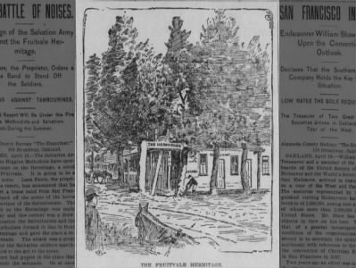 THE FRUITVALE HERMITAGE Sun, Apr 19, 1896 – 13 · The San Francisco Examiner (San Francisco, California) · Newspapers.com
To reach this interesting peak afoot one takes a different route from that he would take were he to ride, and the horseman might vary the trail from that which would be followed with a vehicle. By way of the Hermitage, along the county road, is a popular line of travel; or taking the Redwood road to the summit, and thence along the intermediate ridge line, achieve the same end; or, following Dimond Canyon, and thence through Shepard Canyon, makes an interesting route, but the closest touch is gained a foot, and gives much leisure for investigation.
 |
| Here are, roughly the three routes he suggests; blue from "The Hermitage" at what's now Fruitvale / Macarthur, east on Macarthur, north, uphill on Lincoln until it ends near what's now Joaquin Miller road, then up that alignment to the peak, red north, up what's now 35th / Redwood Road, west on what's now Skyline Blvd to the peak and green, up Dimond Creek to Shepard Creek to the ridgeline, then southeast to the peak. Leona Heights, AKA "Laundry Farm" is at center bottom. |
To one fond of walking among the hills - of foot-grasping with nature - it is well to glide over the level and past the more inhabited places as rapidly as possible, leaving the soulless pavements and rock-beaten roads behind. To tread the unbeaten soil is more inspiring; it yields so graciously underfoot; it really seems to welcome the contact! And how in sympathy one becomes with anything which does him courtesy, and is a gracious yielder! So, leaving Leona Heights, which can be comfortably reached by electric car, and guided by cattle trails and natural landmarks with which numerous visits have familiarized him, the tramper trudges off through the brush and over the sward in close affinity with mother earth and her offspring.
It is wonderful what civil engineers cattle are! Squirrel and deer will beat paths straight up the steepest incline, but the cows have been taught a different lesson. The easiest path to travel over any hilly country upon which they are pasturing will be found to be the one tracked by them. It may be the longest route, but it will usually be found to be the most interesting for in their search after shade, cattle invade many an ideal retreat.
 |
| Boehmer's Ranch / "old inn" would have been about where the Ethiopian Orthodox church is now, on the downslope, southeast side of Redwood Road from the Lincoln Square Shopping Center, as seen on this 1912 Map of Oakland and Vicinity, by the Realty Union |
Traversing the Leona Heights reserve, and crossing the Redwood road at about Boehmer's old inn, the first real slope is at hand. Here one would enjoy a few minutes in inspecting the mines which have been developed within the past few years, and in ascertaining something or the activity from a commercial standpoint; but signs warning the trespasser of the penalty of the law (upon which the statute book is silent) causes ons to respect the request rather than the threat, and to preserve as a mystery the guarded secrets of the tunnel close at hand.
 A Visit to F. Boehmer's Foothill Ranch
Redwood Road
glass house, peak
Knowland's Hill
"blue hill" Mon, Jul 22, 1895 – 4 · Alameda Daily Argus (Alameda, California) · Newspapers.com
A Visit to F. Boehmer's Foothill Ranch
Redwood Road
glass house, peak
Knowland's Hill
"blue hill" Mon, Jul 22, 1895 – 4 · Alameda Daily Argus (Alameda, California) · Newspapers.com[He comes up through where Holy Names University & Safeway are, through the neighborhood where I live - Joaquin Miller Heights - to where Joaquin Miller Park is, now.]
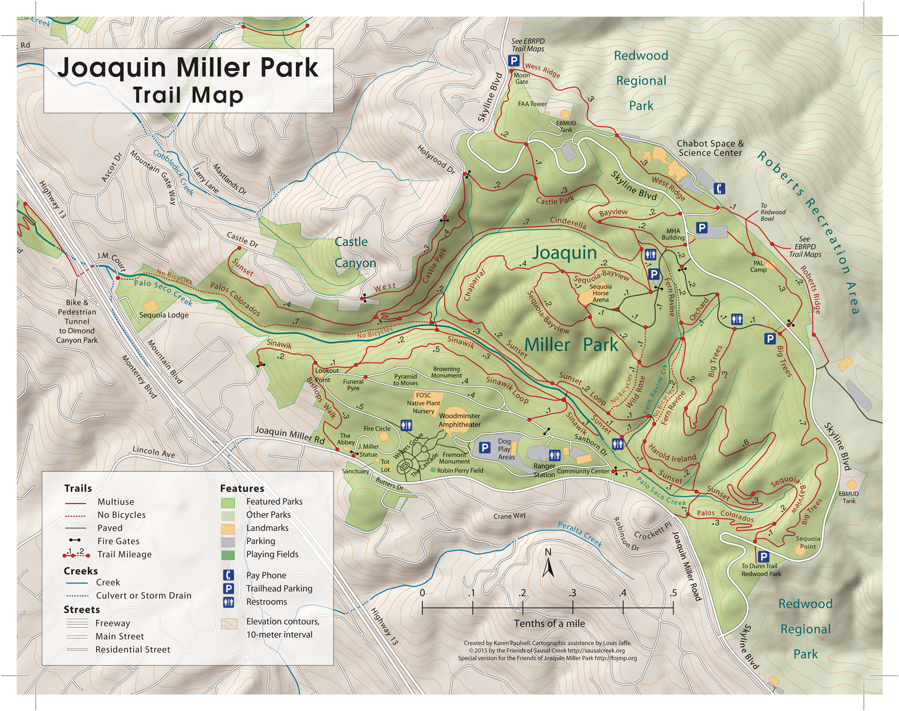
Up, skirting the sheer slopes, following gulches and ravines, through swales and saddles, an hour's walk finds one on the summit road which passes Joaquin Miller's. [Now Joaquin Miller Road] The elevation is sufficient to warrant the taking of many a deep breath as one admires the scene spread out before him but a broader panorama awaits his view; so crawling under the barbed-wire fence lining the road he dips into quite an extensive valley, or vale it might be termed into which converges the three deep, secluded gulches heading into the ridge just this side of the ridge whose summit is Redwood Peak. This valley is richly edged with redwoods, oaks and bays, supplemented by a dense growth of shrubs and ferns: and from its eastern edge the backbones dividing the gutches raise their steep, sun-beaten bosoms in commanding presence, the worthy guardians of the peak which they completely enfold.
 |
| I would bet the "extensive valley, or vale" is the drainage containing Sunset and Palos Colorados trails, and the "three deep, secluded gulches" would approximately line up with the Cinderella, Fern Ravine and Sunset / Big Trees trails. Joaquin Miller Park Trail Map, courtesy of the Friends of Joaquin Miller Park |
Either of these gulches will, if followed, give access to the road leading to the Claussen [Classen] property upon which the peak is situated; but the two southern ones are seldom used. They are rough, and their sides are precipitous. Beautiful groves of redwood deck their beds and margins, the trees here found being as fine specimens of their class as are to be seen this side of the ridge; while vegetation simply runs riot. In many places one will find himself struggling amidst a network of tangled vines, brakes and ferns, supported and reinforced by a dense growth of hazel and huckleberry, but the experience is worth the struggle, for no forest wild could be much more interesting.
The northern gulch is the one most frequented, and the trail along its southern slope has become the highway or most of the pilgrims to this shrine. [I am guessing that trail would now be called Cinderella, or maybe Chaparral trail.] As one saunters along its precipitous way the route yields "alternating shade and seclusion with opening burst of beauty and expanse of view;" and as he gazes back from some point of vantage upon nature's handiwork he cannot help but cogitate upon the wonderful power, as he here observes it, of nature's forces. At his feet lie naked and unsightly the bare worn sides of the channel of last winter's freshets. [Cinderella Creek] Not many months will pass before nature reclothes them, but now they are torn and ragged, and the devastation seems complete. The present summer thread-of-a-stream trickles along the base of the channel, drop by drop in tiny procession; and as these drops fall into a near-by almost dry and stagnant pool they seem as the tears of a contrite child shed over the results of its last mischievous act. In his meditation his eye wanders from this small evidence of the process of disintegration out upon the rugged surfaces before him, and he wonders if all these canyons and valleys were thus formed! Then, overawed by the problem, he permits the pleasure of the present to intervene, and trudges on toward the summit, reflecting:
"The universe of things, how great! The individual man, how small!"
Ag one reaches the summit of the ridge just this side of the ridge bearing the peak, he realizes that knowledge of the topography of a country can be gained only by personal inspection. The slopes as he had looked at them from the bay presented the appearance of maintaining an unbroken line to the top of the peak; and here he has surmounted the summits of two ridges, and the objective point still lies beyond. But this is what makes a hilly country interesting and as he gazes upon the valley lying on down the very backbone of the ridge he has just surmounted, [Redwood Bowl] with its luxurious growth of redwoods and huckleberry, he is the surprised recipient of an unexpected pleasure.
Just a few steps through the redwoods, and John Claussen's [Classen's] ready hand is outstretching to meet one - not at the peak, but within plain view of it. After a few words with this man who loves this vicinity as his very own, one wends his way across the small ravine the further side of which cultivated to fruit and berries rises on to the summit, and aided by the rustic steps the owner's busy hands have built, following the trail through a regular forest of huckleberry, the peak is at last achieved. There is no mistaking it for the spot is monumented by nature, a huge rock fourteen or fifteen feet high occupying the very apex.
 |
| Classen is misspelled Clarsen in this 1894 George Sandow map. |
Just a few steps through the redwoods, and John Claussen's [Classen's] ready hand is outstretching to meet one - not at the peak, but within plain view of it. After a few words with this man who loves this vicinity as his very own, one wends his way across the small ravine the further side of which cultivated to fruit and berries rises on to the summit, and aided by the rustic steps the owner's busy hands have built, following the trail through a regular forest of huckleberry, the peak is at last achieved. There is no mistaking it for the spot is monumented by nature, a huge rock fourteen or fifteen feet high occupying the very apex.
Sitting upon this stately pile and gazing out upon the practically unobstructed view at every hand, [all the trees had been lumbered on the peak, circa 1904] words become inadequate to describe more than the mere geographical points of interest to be here observed. The swells of impressions which surge within one - the inexpressible thoughts rising from the deeper nature - are beyond recording, for these are inspirational benedictions which nature bestows solely upon the individual. The panoramic view is broad and comprehensive: and as he casts a parting glance about him prior to descending, the clouds in arched columns moving in towards the horizon at the Gate arrest his attention, and he is fain to affirm with the poet:
"I've seen on blue enamel of the West.
The clouds all silvery, purple, coppery, make
Great forms before the dazzled vision take
The shape of blazon splendidly impressed."
W. B. KOLLMYER.
 "THE GLORY OF THE HILLS"
Hike to Redwood Peak
John Claussen / Classen
topography Sat, Sep 3, 1904 – 3 · Alameda Daily Argus (Alameda, California) · Newspapers.com
"THE GLORY OF THE HILLS"
Hike to Redwood Peak
John Claussen / Classen
topography Sat, Sep 3, 1904 – 3 · Alameda Daily Argus (Alameda, California) · Newspapers.com
Comments
Post a Comment