 MANY DUSTY ROADS LED OUT OF CITY
Thorn Prince redwoods Thu, May 1, 1952 – Page 136 · Oakland Tribune (Oakland, California) · Newspapers.com
MANY DUSTY ROADS LED OUT OF CITY
Thorn Prince redwoods Thu, May 1, 1952 – Page 136 · Oakland Tribune (Oakland, California) · Newspapers.com
MANY DUSTY ROADS LED OUT OF CITY
Commerce Dictated Routes Of Old Highways
LUMBER TO MARKET
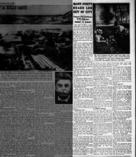
The story of many of Oakland's main arterials is the story of a lusty, expanding city which grew not only because it offered so much to Americans flooding into the area after the Gold Rush but because from the start it supported a thriving industry.Very few realize that, even before the discovery of gold, the Oakland area was active in commerce.
Most of this commerce, before 1840, was in hides, tallow and wheat which moved from Vicente Peralta's rancho to the Embarcadero San Antonio at the foot of what is now 13th Avenue. For this reason the communities of the Peraltas had no need of a network of roads; save for minor trails, El Camino Real was the main arterial and this made possible travel between the various missions.
 |
| Mrs. John Laughland and Mrs. Frank Frost walked from 20th and Telegraph in 1904, to picnic at Park Boulevard and Wellington Ave. Mrs. Frost's husband was grandson of Tom Hill, who painted "Driving of Last Spike." |
MOST NORTHERLY POINT
The most northerly point of this famed road, “The King's Highway" - which many do not realize thrust up the east side of the bay - was at what is now San Pablo (then known as Mission San Pablo).Moving southerly, the highway followed very nearly what is now San Pablo Avenue, crossing Oakland eastward above Lake Merritt, which was then an unbridged slough edged with marsh.
Continuing, it dipped south to the Embarcadero of San Antonio, at which a small wharf accommodated the craft which carried the Peralta products to Yerba Buena and the ships which entered San Francisco Bay to trade.
'HAYWARD ROAD'
From there El Camino Real moved southeast on what later was to be known as "The Hayward Road," and later still by its present name, East 14th Street. San Leandro and Hayward, then not existent, were later to be built on the famed highway.It continued to Mission San Jose and on to Agua Caliente (now Warm Springs) and thence on to the pueblo of San Jose de la Guadalupe, roughly following for its entire distance the route now followed by Highways 50, 9 and 17.
INHERITED TWO
Thus Oakland inherited two of its major arterials from El Camino Real - East 14th Street and San Pablo Avenue, and Oaklanders today ride swiftly over land where once caballeros and vaqueros galloped and rough, solid-wheeled carts slowly creaked behind oxen.With the erection of the first steam sawmills in 1850 lumbering became a major industry. Up to this time timber had been brought out of the hills by hauling it from the woods to what is now Dimond Canyon, at the present intersection of Mountain Boulevard and Park Boulevard. From there it moved down Park Boulevard to what is now 13th Avenue and thence to the San Antonio Embarcadero, where it was transshipped to San Francisco and other points.
OTHER ROUTES NEEDED
This route remained a major lumbering road but the requirements of the expanding communities of the Eastbay made other roads a necessity.In 1851, one of the Castros (who is not otherwise identified in source books) built a wharf at the northeastern shore of what is now Lake Merritt to which hides and lumber from the country north and east of Oakland were brought via the San Antonio Trail which ran through Indian Gulch (now Trestle Glen) for. shipment to San Francisco by means of light craft.
Some maps show an extension of El Camino Real above Lake Merritt and it is probable that the Trestle Glen road was thus linked with the San Antonio Embarcadero.
LUMBER CARRIERS
At this time - 1851 and for a few years thereafter - nearly all east-west roads were built to carry lumber to market. The Park Boulevard - East 13th Avenue road, which lay to the east of unbridged Lake Merritt, could not serve the downtown Oakland area nor was it practicable for hauling from the Moraga woods, which lay to its east.For this reason a new road was built in 1852 which roughly followed the present line of Broadway to what is now Broadway Terrace, thence climbed to what is now Mountain Boulevard, and thence continued to Dimond Canyon and the outflowing lumber from the redwoods.
 |
| From "East Bay Hills, A Brief History" by Amelia Sue Marshall |
BUILT IN 1853
Still another road was built in 1853 which lay to the east of the Park Boulevard road. This tapped the Moraga woods and followed approximately the present line of Redwood Road to 35th Avenue and thence down, finally swinging west to San Antonio Embarcadero via East 14th Street.Completion of this road opened a new market, that in Alameda. High Street was continued northward to the base of the hills, where it joined the Redwood Road - East 35th Street road.
Present-day High Street does not follow the original road faithfully.
In the same year, 1853, Hiram Thorn built one of Oakland's famous roads, long known as Thorn Road. It was a shorter route from the Thorn lumber mill to the Embarcadero since it followed San Leandro Creek to the skyline, then ran down Thornhill Canyon to approximately Dimond Canyon at which point its traffic moved onto Park Boulevard, or alternately onto the Broadway Terrace route to Oakland.
PARTS SURVIVE
Parts of Thorn Road are now Thornhill Drive and Sobrante Road; a part has been abandoned.
There were other lumbering roads, notably Prince Road which fell into disuse at the end of the sawmill era in 1860 (the redwoods by then had been cut away); but those listed above have remained in the Oakland street system. "... the giant redwoods were not wasted," writes Sherwood D. Burgess in an excellent monograph on Oakland's redwoods published in the California Historical Society Quarterly." ... they played an important role in the development of the San Francisco Bay region."
While San Pablo Avenue (first El Camino Real, then The County Road, then San Pablo Road) and East 14th Street are Oakland's oldest thoroughfares, Telegraph Avenue is a close runner-up.
EARLY TELEGRAPH
It was first known as Telegraph Road, earning its name from the telegraph wires which lined the road. The first street to reach out to mid-Oakland, it continued as a dusty country road to what is now Claremont Avenue, wound into the hills and along the north branch of the Temescal, finally progressing into Fish Ranch Road and thence on to Sacramento.
As with so many other cities, Oakland, like Topsy, just grew.
So did its contemporary towns - Clinton, Brooklyn, Fruit Vale, Lynn, Eden, Murray, Washington, and the areas of Oakland proper.
Those who planned the streets of these communities could not have foreseen the day in 1952, when they would be combined in one great metropolitan city, with the outstretching streets and avenues of one community meeting that of the next, and all bound together by the great roads of over 100 years ago.
Comments
Post a Comment