Oakland's Forgotten Creeks
.jpg)
(First in a series of five articles. Tomorrow - The Creeks in their heyday.)
Steelhead trout and salmon wriggled up Oakland streets to spawn.
Elk gathered at a water hole on the Mills College campus. A mountain lion, stalking them, was slain by hunters.
Huge redwood logs moved slowly down Fruitvale Avenue on skids drawn by lumbering oxen.
Naked Indians, literally stewed in their own perspiration, ran wild on Claremont Avenue.
But all that was before Oakland had streets, long before, Mills College was
established, when Fruitvale Avenue was a trail to the timber region. The
Indian village with its "temescal" has long since given way to homes and apartment houses on
the gore of Telegraph and Claremont Avenues.
FORGOTTEN CREEKS
That was in the days when Oakland's forgotten creeks were sometimes swollen
torrents, never less than flowing brooks, "babbling down from their mountain fastnesses."
This is the story of those forgotten creeks, the 21 streams and
their innumerable branches which had their headwaters in the
San Antonio forests, which drained the oak-covered slopes, the open fields of grass and flowers,
the marshy lowlands on the east side of the Bay. Forgotten they are today, or
almost so.
Some old-timers remember them. They recall the fishing,
the hunting, the picknicking of their childhood. They remember lanes of
willows and alders, and maples, dense clumps of strawberries, blackberries,
and huckleberries. They remember masses of golden poppies and blue lupines,
the quail, the robins, doves, meadow larks, squirrels, cottontails, deer,
coyote, and foxes. They recall lurid tales, if not the actual sight, of elk
and antelope and bear.
REACH DEAD-END
But the life, the sparkle, the part creeks
played in Oakland's early history, are very nearly forgotten. Today they exist
only in some parks, or as adjuncts to landscaped gardens. For the most part
they are hidden beneath homes and buildings and streets and factories. In some
sections they appear as brush-filled ditches, dead-ending streets to choke
traffic, roaring with muddy torrents after a winter storm. A convenient,
although illegal, place for dumping refuse.
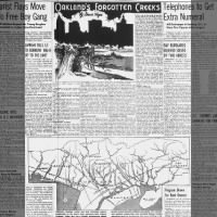
Twenty-one creeks drained the Rancho San Antonio when, in 1820, it was granted to Sergeant Luis Maria Peralta, in recognition of his military services to the King of Spain. His domain extended from Cerrito Creek on the north to San Leandro Creek on the south, encompassing the area of Albany, Berkeley, Emeryville, Piedmont, and all of Oakland, undoubtedly the richest grant in all California, in point of its eventual value.
Cerrito today forms the northern boundary of Alameda County, establishing city limits of Albany and Berkeley. Codornices ranges from what is now the Euclid Avenue reservoir and marks the boundary line between Albany and Berkeley.
STRAWBERRY CREEK
Strawberry, with
headwaters in the hills above the University of California campus, passes
through those grounds and down to the Bay at the foot of University Avenue.
The
city engineer's office has been unable to establish names for two creeks next
to the south.
[According to the
Creek & Watershed Map of
Oakland & Berkeley, the next two are Potter Creek and Derby Creek. - MF] One is short, running from Grove Street, between Dwight Way and Channing Way,
to the foot of Ashby Avenue. The other has branches on either side of the
lands of the
California School for the Deaf, and discharges into the Bay at 64th Street.
Longest of all is Temescal, with four distinct branches originating near the top of the ridge along the county line. Two branches converge in what is now Lake Temescal, while another parallels Claremont Boulevard. From the main confluence near Forest and Miles Streets, the creek swings around the gore of Claremont and Telegraph Avenues and moves to a Bay outlet between 47th and 53rd Streets.
Four of the creeks feed into Lake Merritt. One joins the well-known Cemetery Creek, a Rockridge stream, and a Broadway branch, to enter the west arm of the Lake. Another drains the Grand Lake district. It and a third, running along Lake Shore Avenue and through Trestle Glen, formerly Indian Gulch, discharge at the northern arm. The fourth parallels Park Boulevard.
Two small streams lie beside 14th Avenue [Sausal Creek] and 23rd Avenue. [Peralta Creek] Dimond Canyon is the locale for Sausal, which runs from headwaters at the top of Park Avenue and in Sequoia Park, all the way down Fruitvale Avenue.
Peralta and Courtland have a common outlet into a slough of San Leandro Bay, near 50th Avenue. The former has a maze of branches, while the latter parallels High Street for most of its length. Into the same slough empties a short creek which runs down 54th Avenue, and Seminary, which cuts across a corner of the Mills College campus and runs down Seminary Avenue. [54th Avenue Creek]
OTHER STREAMS
Through the college grounds and the
Havenscourt district runs
Lion, Arroyo Viejo, with
origin points in the
Oak Knoll
section, crosses Foothill and Bancroft, then goes down 78th Street to East
14th, over to 74th, and out to San Leandro Bay. It uses the same outlet as
Elmhurst, which comes all the way across from above San Leandro. Last of the
creeks, and largest of all, is
San Leandro,
running from Lake Chabot to the end of San Leandro Bay.
Those are the 21 creeks which drain the city, and they do not include the most famous of all - San Antonio Creek. It actually was not a creek, but a slough of the Bay that, through channel dredging and shore fills, long ago became the Estuary, with its northern arm transformed into Lake Merritt.
It established the location of the center of business and industry which
Peralta's sons strove futilely to block. On its shore appeared the pioneer
towns of Brooklyn and
Clinton from which, along the 21
creeks, spread the residential sections of what grew swiftly into the City of
Oakland.
.jpg)

 Oakland's Forgotten Creeks #1 28 Jan 1947, Tue
Oakland Tribune (Oakland, California) Newspapers.com
Oakland's Forgotten Creeks #1 28 Jan 1947, Tue
Oakland Tribune (Oakland, California) Newspapers.com
See also Creek & Watershed Map of Oakland & Berkeley.
Comments
Post a Comment