Trail History: Playground for Motorcyclists, AKA Redwood Motorcycle Hill, AKA Rutwood, AKA Soaring Hawk Trail
History
There are at least two Grass Valleys in California.
The one we know in Oakland, in 2023
is near the Oakland Zoo, at the bottom of Golf Links road. In
the middle of the 20th century Grass Valley was the name of
the valley bordered by Redwood Road on the north, San Leandro reservoir to
the east, Lake Chabot on the south and Skyline Boulevard on the west. The
Grass Valley trail runs
down much of its length. Before
the East Bay Regional Park District (EBRPD) was formed,
it was one of the areas considered for purchase by the East Bay Regional
Park Board, along with Redwood Canyon, Sibley and Wildcat Canyon. In 1951
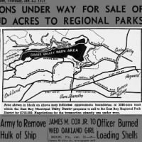
the sale of Grass Valley by the East Bay Municipal Utility District (EBMUD) to
EBRPD was proposed, and in 1952, it was sold. In 1965
Grass Valley Park was renamed Anthony Chabot Regional Park.
 Map of GRASS VALLEY PARK AREA 25 Jan 1951, Thu
Oakland Tribune (Oakland, California) Newspapers.com
Map of GRASS VALLEY PARK AREA 25 Jan 1951, Thu
Oakland Tribune (Oakland, California) Newspapers.com
A four-lane, mountain boulevard was planned that would run through the park. The 1956 Southeast Hill Area Plan, "a section of the comprehensive master plan of Oakland" stated, "As proposed in the 1948 Freeways and Major Streets Section of the Master Plan, Skyline Boulevard is shown extending to Estudillo Avenue in San Leandro and to Lake Chabot Road near Castro Valley." You can see the planned development, including fire hydrants, if you hike or ride the Goldenrod trail from where Skyline narrows to two lanes until it reaches Grass Valley road. Thankfully this didn't happen.
Opening day for Grass Valley Park was primarily an equestrian affair, but
the motorcycle clubs also got a section of the park for their own use. A
search of the minutes of the EBRPD for "motorcycles"
returns some interesting history:
Grass Valley Regional Park,
a. Completed construction of a two-mile motorcycle trail in an area set aside for motorcyclists to use.
b. Installed new carved signs at the motorcycle area.
c. Installed barriers to keep motorcyclists out of each gate entering the trails in Grass Valley.
d. Installed 200' of barriers along the boundary where cars were getting through Marciel Gate.
e. Bladed all fire roads in Grass Valley.
MINUTES REGULAR MEETING EAST BAY REGIONAL PARK BOARD, JUNE 29, 1954
MINUTES REGULAR MEETING EAST BAY REGIONAL PARK BOARD, JULY 27, 1954Letter of July 22, 1954, received from Bud Dutot, Treasurer of the Oakland Motorcycle Club expressing on behalf of his group their thanks for providing a "playground for Motorcyclists". He states that his club will do everything within its power to cooperate with the Regional Park District's rules regarding motorcycles and will do their best to see that motorcycles do not venture on to the bridle trails.
These undated articles - found on Ebay - reference the new "playground for Motorcyclists":
MOTORCYCLISTS' PLAYGROUND - Oakland Riders Enjoy Exclusive Use of City Park Trail - Motorcyclist - date? By Don R. Hammitt
Photos from that article:

|
| San Leandro Knights MC members McMeans, Barnes, Marino, Hickman and McKinney at entrance to rugged two-mile trail in Oakland. |

|
| The mountainous trail is punctuated with sharp switchbacks which keep the riders alert. Course is on city-owned property, and came into being after local clubs asked city officials to supply them. with an area to ride in, so that they wouldn't have to use the horseback riding trails. |
And those places now:
 |
| The TRAIL CLOSED NO ENTRY SIGN is about where the MOTORCYCLE TRAIL sign is, in the first photo. White dashed lines show trail alignment behind the foliage. |
 |
| Much has changed in 67 years, but this could be the location of the second photo, if the original photographer was up in a tree. Dashed lines show an old motorcycle rut. |
Oakland Playground for Motorcyclists By Bud Dutot
Photo from that article:

|
| Group of cyclists ready to enjoy new playground for motorcycles. Sign reads "For Motorcycle Use Only". |
And that place now:
 |
| Dashed white lines show the trail alignment, behind the foliage. Signs are at approximately the same locations. |
Motorcycle hillclimbs had long been a popular pastime in Oakland, and the motorcycle riders now had their own special area, but by 1964 EBRPD had to explicitly banned motorbikes on hiking and bridle trails and in the same year:
Park District Gen. Mgr. William Perm Mott Jr. has revealed his staff is looking for a 500-acre site in Eastern Alameda County which could accommodate isolated "mechanical park."
Note that the motorcyclists had significant bargaining power with the park
district:
MOTORCYCLE CLUBS
Mrs. Marjorie Gills was spokesman for the Citizens' Council on Motorcycles In requesting an allocation of funds be set aside in next year's budget for a mechanical park.
Since her groups supported and worked for the District's tax Increase, she said it was hoped funds could be set aside to accommodate motorcyclists.
MINUTES PUBLIC HEARING ON 1971-72 DISTRICT BUDGET EAST BAY REGIONAL PARK DISTRICT August 10, 1971
The board was in agreement, motorcycles would have to find a new home. Motorcyclists continued to use the area, doing seeding and erosion work and otherwise having a good time. (part 2) They caused problems with law enforcement. In 1980 they still had a 67-acre motorcycle trail area, but by 1985 the park district had found them a new home in Brentwood (part 2) even though the Chabot bikers wanted trails to stay.
In 1988, after the motorcycles left, the state of California appropriated $200,000 to restore the "Redwood Motorcycle Hill" area: Restoration funds OKd for popular biking hill. Restoration work was performed, and the trail was renamed Soaring Hawk trail.
 Under wraps 28 Feb 1986, Fri Oakland Tribune (Oakland, California) Newspapers.com
I wasn't able to find much on the internet about the renaming of the trail, just this:
Neighboring Anthony Chabot Regional Park has a large wooded family campground, an 18-hole golf course, and horse stables. There used to be a shooting range, an archery range, and an off-road motorcycle area (where the Soaring Hawk Trail is now), but those have been closed, making the park much more peaceful. Today the developed areas are all at the southern end of the park, leaving the rest of the park surprisingly remote and woodsy.
http://www.redwoodhikes.com/EastBay/Chabot.html
Experiences
The area was nicknamed "Rutwood." You can see the deep channels, off to the
side of Soaring Hawk, still.
I grew up in the Oakland hills so we dirt biked all over up there back then, one favorite place was where Merit College is , it use to be an old quarry we use to ride all over there and down redwood road going towards Castro valley in the 60's there use to be a dirt bike park called redwood hill climbs then it became rutted up so bad we called it rutwood hill climbs then they closed it in the early 70's it was run by the east bay regional park district, I bet not to many people remember that place.
Share stories of off road riding in Bay Area back in the day
Here's a recollection of the Redwood Road Hill Climbs, AKA Rutwood, found on
facebook:
Redwood Road Hillclimbs aka Rutwood. Located in the east bay hills between Oakland and Castro Valley was a motoX destination for many years up until it was closed in the early 70s. Husqvarna had a dealership on east 14th in Oakland, and the factory team would practice at Rutwood just up the hill. That green C20 (probably built in Fremont) is a brand new truck in this pic. Now this location is pretty much covered unrecognizable, there’s many rules against the use of mountain bikes on the trails and of course today the road is full of wanabe Lance Armstrongs with their overly expensive bikes and tights full of sponsorships that aren’t paying them.
Closed in 1984
George Golling
 |
| From Facebook |
That place, now:
 |
| That place, now is almost unrecognizable. If you go there, you can see the shape of the place, but nature has filled it with trees and bushes. Note road and electrical tower at top left. |
This photo of the old staging area is now the "early exit," if traveling north-bound on Soaring Hawk trail, right here. The park district has recently installed signs, after that early exit telling trail users TRAIL END.

Of course, the trail doesn't end, but continues - as it has since 1954 - to its exit opposite the Bort Meadow Staging Area. You can see how it originally looked in the pair of photos above, the first captioned "Group of cyclists ready to enjoy new playground for motorcycles." I believe the park district wants to decommission that section of trail, and has started ticketing people using it, because it has an unsafe exit. The 2023 Proposed Budget for EBRPD has:
| Project Name | Project# | Location | Appropriation | Total Budget | Expend to Date |
|---|---|---|---|---|---|
| Realign Soaring Hawk Trail | 553800 | Anthony Chabot | 0 | 50,000 | 0 |
Comments
Post a Comment