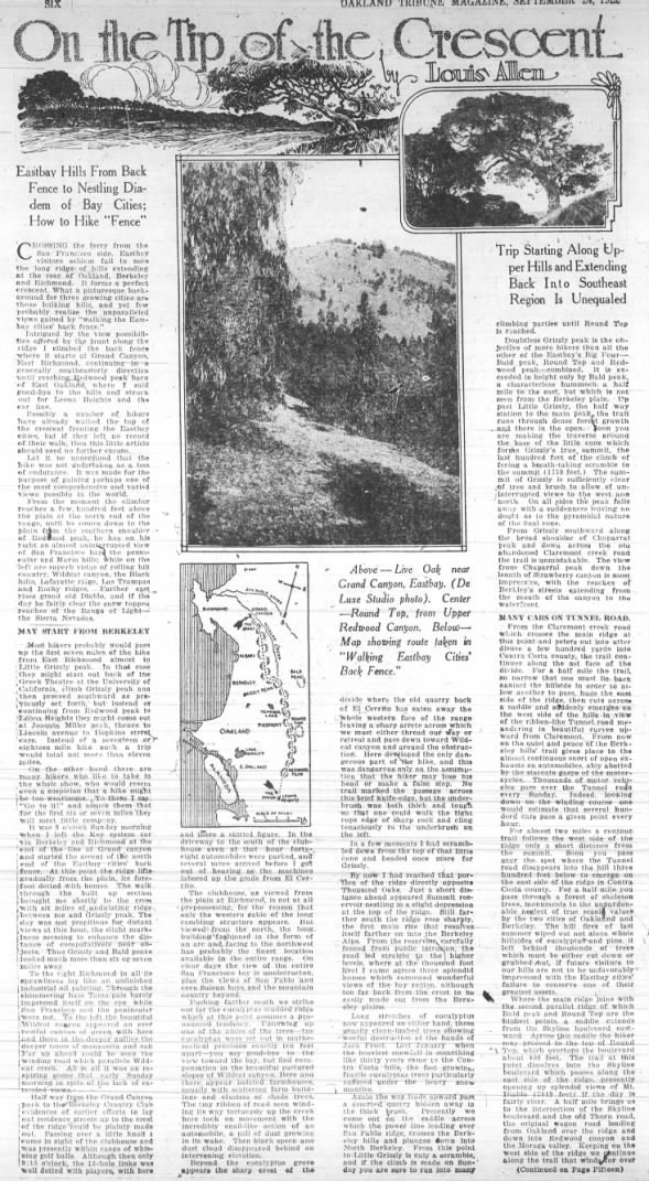
 |
| Above - Live Oak near Grand Canyon, Eastbay. (De Luxe Studio photo). Center - Round Top, from Upper Redwood Canyon. Below - Map showing route taken in "Walking Eastbay Cities' Back Fence." |

 |
| The above map, georeferenced with named landmarks |
On the Tip of the Crescent
by Louis Allen
Eastbay Hills From Back Fence to Nestling Diadem of Bay Cities; How to Hike "Fence"
CROSSING the ferry from the San Francisco side, Eastbay visitors seldom fail to note the long ridge of hills extending at the rear of Oakland, Berkeley and Richmond. It forms a perfect crescent. What a picturesque background for three growing cities are these hulking hills, and yet few probably realize the unparalleled views gained by "walking the Eastbay cities' back fence."Intrigued by the view possibilities offered by the jaunt along the ridge I climbed the back fence where it starts at Grand Canyon, East Richmond, continuing in a generally southeasterly direction until reaching Redwood peak back of East Oakland, where I said good-bye to the hills and struck out for Leona Heights and the car line.
Possibly a number of hikers have already walked the top of the crescent fronting the East bay cities, but if they left no record of their walk, then this little article should need no further excuse.
Let it be understood that the hike was not undertaken as a test of endurance. It was made for the purpose of gaining perhaps one of the most comprehensive and varied views possible in the world.
From the moment the climber reaches a few hundred feet above the plain at the north end of the range, until he comes down to the plain from the southern shoulder of Redwood peak, he has on his right an almost uninterrupted view of San Francisco bay the peninsular and Marin hills; while on the left are superb vistas of rolling hill country, Wildcat canyon, the Black hills, Lafayette ridge, Las Trampas and Rocky ridges. Farther east rises grand old Diablo, and if the day be fairly clear the snow topped reaches of the Range of Light - the Sierra Nevadas.
MAY START FROM BERKELEY
Most hikers probably would pass up the first seven miles of the hike from East Richmond almost to Little Grizzly peak. In that case they might start out back of the Greek Theatre at the University of California, climb Grizzly peak and then proceed southward as previously set forth, but instead of continuing from Redwood peak to Leona Heights they might come out at Joaquin Miller park, thence to Lincoln avenue to Hopkins street cars. Instead of a seventeen or eighteen mile hike such a trip would total not more than eleven miles.On the other hand there are many hikers who like to take in the whole show, who would resent even a suspicion that a hike might be too wearisome. To these I say, "Go to it!" and assure them that for the first six or seven miles they will meet little company.
 |
| "June 1909 - A line to Grand Canyon Park (today’s Alvarado Park) opens. The line runs north on San Pablo Avenue from Macdonald Avenue and then east on Park Avenue (now McBryde Avenue) to the park entrance. Grand Canyon Park was built in 1909 by real estate developer Bernhard Shapiro to induce people to buy property in his nearby subdivisions." - from East Shore & Suburban Railway & other El Cerrito Railroad Chronology |
It was 9 o'clock Sunday morning when I left the Key system car via Berkeley and Richmond at the end of the line at Grand canyon and started the ascent of the north end of the Eastbay cities' back fence. At this point the ridge lifts gradually from the plain, its forefoot dotted with homes. The walk through the built up section brought me shortly to the crest with six miles of undulating ridge between me and Grizzly peak. The day was not propitious for distant views at this hour, the slight murkiness seeming to enhance the distance of comparatively near objects. Thus Grizzly and Bald peaks looked much more than six or seven miles away.
To the right Richmond in all its sprawliness lay like an unfinished industrial oil painting. Through the shimmering haze Tamalpais barely impressed itself on the eye while San Francisco and the peninsular were not. To the left the beautiful Wildcat canyon appeared an ever restful canvas of green with here and there in the deeper gullies the deeper tones of manzanita and oak. Far up ahead could be seen the winding road which parallels Wildcat creek. All in all it was an inspiring scene that early Sunday morning in spite of the lack of extended views
Half way from the Grand Canyon park to the Berkeley Country Club evidences of earlier efforts to lay out residence streets up to the crest of the ridge could be plainly made out. Passing over a little knoll I came in sight of the clubhouse and was presently within range of whizzing golf balls. Although then only 9:15 o'clock, the 18-hole links was well dotted with players, with here and there a skirted figure. In the driveway to the south of the clubhouse even at that hour forty-eight automobiles were parked, and several more arrived before I got out of hearing as the machines labored up the grade from El Cerrito.
 |
| From google maps |
Pushing farther south we strike out for the eucalyptus studded ridge which at this point assumes a pronounced tendency. Following up one of the aisles of the trees - the eucalyptus were set out in mathematical precision exactly ten feet apart - you say good-bye to the view toward the bay, but find compensation in the beautiful pastured slopes of Wildcat canyon. Here and there appear isolated farmhouses, usually with scattering farm buildings and clusters or shade trees, The tiny ribbon of road seen winding its way tortuously up the creek here took on movement with the incredibly snail-like action of an automobile, a pall of dust growing in its wake. Then black speck and dust cloud disappeared behind an intervening elevation.
Beyond the eucalyptus grove appears the sharp crest of the divide where the old quarry back of El Cerrito has eaten away the whole western face of the range leaving a sharp arrete across which we must either thread our way or retreat and pass down toward Wildcat canyon and around the obstruction. Here developed the only dangerous part of the hike, and this was dangerous only on the assumption that the hiker may lose his head or make a false step. No trail marked the passage across this brief knife-edge, but the underbrush was both thick and tough so that one could walk the tight rope edge of sharp rock and cling tenaciously to the underbrush on the left.


In a few moments I had scrambled down from the top of that little cone and headed once more for Grizzly.
By now I had reached that portion of the ridge directly opposite Thousand Oaks. Just a short distance ahead appeared Summit reservoir nestling in a slight depression at the top of the ridge. Still farther south the ridge rose sharply, the first main rise that resolves itself farther on into the Berkeley Alps. From the reservoir, carefully fenced from public intrusion, the road led straight to the higher levels, where at the thousand foot level I came across three splendid homes which command wonderful views of the bay region, although too far back from the crest to be easily made out from the Berkeley plains.
 |
| From google maps |
 |
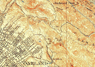
| I think the road he's talking about is now called Grizzly Peak Blvd, seen southwest of the ridgeline in this screen capture from 1915 USGS maps. |
 |
| King Winter Traces Foothills in Phantom White - Oakland Tribune, 30 Jan 1922, Mon, Page 13 |
 |
| Look closely at this 1915 map, there are no roads along the ridge where he describes his hike. Now we could travel along Grizzly Peak Blvd. |
From Grizzly southward along the broad shoulder of Chaparral peak and down across the old abandoned Claremont creek road the trail is unmistakable. The view from Chaparral peak down the length of Strawberry canyon is most impressive, with the reaches of Berkley's streets extending from the mouth of the canyon to the waterfront.
 |
| Claremont Creek road would be Claremont Avenue to Fish Ranch road. Read more about it here. |

MANY CARS ON TUNNEL ROAD.
From the Claremont creek road which crosses the main ridge at this point and peters out into utter disuse a few hundred yards into Contra Costa county, the trail continues along the east face of the divide. For a half mile the trail, so narrow that one must lie back against the hillside in order to allow another to pass, hugs the east side of the ridge, then cuts across a saddle and suddenly emerges on the west side of the hills in view of the ribbon-like Tunnel road meandering in beautiful curves upward from Claremont. From now on the quiet and peace of the Berkeley hills' trail gives place to the almost continuous snort of open exhausts on automobiles, ably abetted by the staccato gasps of the motorcycles. Thousands of motor vehicles pass over the Tunnel road every Sunday. Indeed, looking down on the winding course one would estimate that several hundred cars pass a given point every hour.
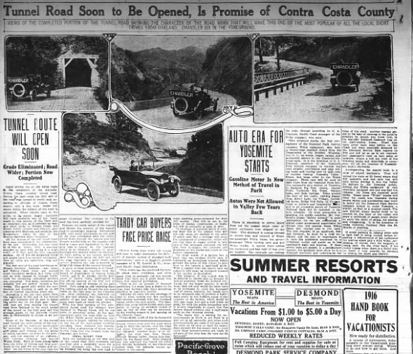 Tunnel Road Soon to Be Opened, Is Promise of Contra Costa County Photos Sun, May 14, 1916 – Page 44 · Oakland Tribune (Oakland, California) · Newspapers.com
Tunnel Road Soon to Be Opened, Is Promise of Contra Costa County Photos Sun, May 14, 1916 – Page 44 · Oakland Tribune (Oakland, California) · Newspapers.com
For almost two miles a contour trail follows the west side of the ridge only a short distance from the summit. Soon you pass over the spot where the Tunnel road disappears into the hill three hundred feet below to emerge on the east side of the ridge in Contra Costa county. For a half mile you pass through a forest of skeleton trees, monuments to the unpardonable neglect of true scenic values by the two cities of Oakland and Berkeley. The hill fires of last summer wiped out not alone whole hillsides of eucalyptus and pine, but left behind thousands of trees which must be either cut down or grubbed out, if future visitors to our hills are not to be unfavorably impressed with the Eastbay cities' failure to conserve one of their greatest assets.
 FIRE SWEEPS HILLS BACK OF BERKELEYWed, Sep 28, 1921 – Page 1 · Oakland Tribune (Oakland, California) · Newspapers.com
Where the main ridge joins with the second parallel ridge of which Bald peak and Round Top are the highest points, a saddle extends from the Skyline boulevard eastward. Across this saddle the hiker may proceed to the top of Round Top, which overtops the boulevard about 400 feet. The trail at this point dissolves into the Skyline boulevard which passes along the east side of the ridge, presently opening up splendid views of Mt. Diablo (3849 feet) if the day is fairly clear. A half mile brings us to the intersection of the Skyline boulevard, and the old Thorn road, the original wagon road leading from Oakland over the ridge and down into Redwood canyon and the Moraga valley. [More about that here. Redwood canyon contains the town of Canyon and San Leandro creek.] Keeping on the west side of the ridge we continue along the trail that winds for over three miles with little grade along the Diablo side of the divide and up to the northern slope of Redwood peak.


From the Thorn road intersection to the top of Redwood peak, the hike is one of the most interesting in all the hills. The Contra Costa hills country is unfolded for almost the entire length of the trail, offering surprising vistas of rolling ranges to the east sparsely forested and with here and there outcropping rock formations. At the point half way between Round Top and Redwood peak, where the trail crosses the Shepard creek road the hiker may take the trail leading to the right, which presently takes him into the unfinished extension of the Skyline boulevard toward Redwood peak. Since this road is now virtually cut through to its destination, the hiker may follow it to the point on the side of Redwood peak whence it is an easy scramble to the top of the mountain.

 |
| The beginnings of Skyline Boulevard branches in two directions, one to the Classen home near Redwood Peak, and the other goes into what's now Joaquin Miller Park. I'm still figuring that out, but it might have been the Silva / Sylva / Silver home. Father McNally had a ranch up there, as well. |

Returning from the summit the hiker will have no trouble reaching the private road running down the southwest shoulder of the peak, connecting with the county road. The hike comes to a close at Leona Heights, where the Mills College cars may be reached. If the hiker prefers to come out nearer Oakland, he may return from Redwood peak, hitting the trail that leads westward past the road construction camp. This trail comes out on the Joaquin Miller road only a quarter mile above the Miller estate. It is an easy hike form the Heights to Lincoln avenue, thence to Hopkins street, where connection may be made with a street car line running into Oakland.


Don't neglect to carry a canteen of water. I came across only one spot where drinkable water could be had; and that was a spring on the southwestern slope of the Redwood peak, virtually at the end of the walk. From 9 o'clock that morning until 2 in the afternoon I had to use insipid canteen water, but was glad to get it. Do not make the mistake of trying to traverse the Eastbay cities' back fence without an adequate supply of water. Remember you are high in the air at all times, and plurality of springs at the higher levels is not a characteristic of the Contra Costa hills.
More articles by Louis Allen:
More articles by Louis Allen:
- The Hiker's Paradise by Louis Allen - Oakland Tribune 07 May 1922, Sun Page 77
- Eastbay District Has Many Sites For Outings - Oakland Tribune - 03 Jun 1923, Sun - Page 37
- Short Hikes for Sunday - Oakland Tribune 26 Aug 1923, Sun
 On the Tip of the Crescent, part 2 TO BLOG Sun, Sep 24, 1922 – Page 73 · Oakland Tribune (Oakland, California) · Newspapers.com
Comments
Post a Comment