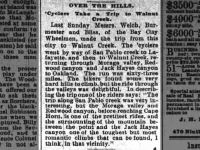
OVER THE HILLS.
'Cyclers Take Trip to Walnut Creek.
The run was sixty-three miles. The bikers found some very hard hills to climb, but the ride through the valleys was delightful. In describing the trip one of the riders says: "The trip along San Pablo creek was very interesting, but the Moraga valley and Redwood canyon, before reaching Cape Horn, is one of the prettiest rides, and the surmounting of the mountain between the point and the Jack Hayes canyon one of the toughest but most romantic climbs that can be found, I think, in that vicinity."
 Over The Hills
'Cyclers Take a Trip to Walnut Creek. Wed, May 8, 1889 – Page 3 · Oakland Tribune (Oakland, California) · Newspapers.com
Over The Hills
'Cyclers Take a Trip to Walnut Creek. Wed, May 8, 1889 – Page 3 · Oakland Tribune (Oakland, California) · Newspapers.com
It's 1889. The safety bicycle has just been invented, but none of these "wheelmen" would have anything to do with it. It doesn't even enter the lexicon (in my case, archived newspapers from the San Francisco Bay Area) for another year or two, and safeties are still not in regular use until about 1893. These people were riding "ordinaries", AKA "penny farthings." Think about climbing, or descending hills with those. Their final climb is a doozy. They were probably on foot if the grade was above 4%.
It's funny. A 63-mile ride over dirt roads, through remote country on a penny farthing must have been plenty real and concrete to these people; sweat, blood, beautiful views, hunger pangs, thirst, water where you can find it. All we have left of their ride is this little bit of ephemera, this text. I bet the newspaper still exists somewhere, from which the image of this article was scanned. I retrieved it via a web service called newspapers.com, transmitting it as electrons across cables and wires, and through the air across radio frequencies. I then turn the image into text, and then share it back to all of you, across more wires, space and time. Someone may be reading this another 120 years from now. All I have to go by is these words, and old maps from about the same time. (Same; digital copies of analogs, somewhere, from another time.) I can't verify any of this with any living human. These people have been dead for at least seventy years. Roads have changed, changed names, appeared, disappeared. Bodies of water occupy space that used to be air, and earth has been moved, tunneled.
Here's my best guess of where they went:
I'm going to use modern names. I imagine them starting at the intersections of 14th Street, Broadway and San Pablo Avenues, because that's City Hall. That's Oakland, right? And also, because if I was going to ride to "San Pablo Creek", I'd want a flat route that existed in 1889, and it's a straight shot down flat San Pablo Avenue to the road that follows San Pablo Creek, what's now San Pablo Dam road. Interestingly, we still ride basically the same route; out San Pablo Ave, back on San Pablo Dam Road. Cyclists call it "the flats". These riders veer left toward Walnut Creek, then return on what are now trails, not the way we'd finish "the flats" now. (Wildcat, Pinehurst or Redwood) Now Frank Ogawa Plaza is where San Pablo Avenue would have branched. Let's imagine we're on bikes, meaning we can still go that way. Let's push off.
Over The Hills
'Cyclers Take a Trip to Walnut Creek. Wed, May 8, 1889 – Page 3 · Oakland Tribune (Oakland, California) · Newspapers.com
It's 1889. The safety bicycle has just been invented, but none of these "wheelmen" would have anything to do with it. It doesn't even enter the lexicon (in my case, archived newspapers from the San Francisco Bay Area) for another year or two, and safeties are still not in regular use until about 1893. These people were riding "ordinaries", AKA "penny farthings." Think about climbing, or descending hills with those. Their final climb is a doozy. They were probably on foot if the grade was above 4%.
It's funny. A 63-mile ride over dirt roads, through remote country on a penny farthing must have been plenty real and concrete to these people; sweat, blood, beautiful views, hunger pangs, thirst, water where you can find it. All we have left of their ride is this little bit of ephemera, this text. I bet the newspaper still exists somewhere, from which the image of this article was scanned. I retrieved it via a web service called newspapers.com, transmitting it as electrons across cables and wires, and through the air across radio frequencies. I then turn the image into text, and then share it back to all of you, across more wires, space and time. Someone may be reading this another 120 years from now. All I have to go by is these words, and old maps from about the same time. (Same; digital copies of analogs, somewhere, from another time.) I can't verify any of this with any living human. These people have been dead for at least seventy years. Roads have changed, changed names, appeared, disappeared. Bodies of water occupy space that used to be air, and earth has been moved, tunneled.
Here's my best guess of where they went:
 |
| This is an 11.6 MB image file, exported at 600dpi from QGIS 3.10. Download it from this link, view it locally, zoom in to see the detail. The two maps, left and right are USGS topographical maps from San Francisco (1895) and Concord (1897) quadrangles. I drew where I think the riders went with a blue vector line, tracing the roads I think they used on the maps, which roughly align with modern roads. I made this using maps from the USGS and modern base maps. If you want the source files, leave me a comment. The USGS maps do not perfectly align with my modern base maps. My blue line traces the old maps, and is similarly displaced from the modern base maps. |
I'm going to use modern names. I imagine them starting at the intersections of 14th Street, Broadway and San Pablo Avenues, because that's City Hall. That's Oakland, right? And also, because if I was going to ride to "San Pablo Creek", I'd want a flat route that existed in 1889, and it's a straight shot down flat San Pablo Avenue to the road that follows San Pablo Creek, what's now San Pablo Dam road. Interestingly, we still ride basically the same route; out San Pablo Ave, back on San Pablo Dam Road. Cyclists call it "the flats". These riders veer left toward Walnut Creek, then return on what are now trails, not the way we'd finish "the flats" now. (Wildcat, Pinehurst or Redwood) Now Frank Ogawa Plaza is where San Pablo Avenue would have branched. Let's imagine we're on bikes, meaning we can still go that way. Let's push off.
The 'cyclers went by way of San Pablo creek...San Pablo Avenue is long and straight. I've heard the miners followed it to the gold country. It was Camino de la Contra Costa, built by the Spanish, probably following native American trails. Here's another history of it. In the town of San Pablo we cut right, crossing what's now Highway 80 and head southeast on San Pablo Dam Road. Here's some history and pictures of old stuff along the road. If you look closely, the old road has these people riding along what's now the bottom of San Pablo Reservoir. Because roads follow creeks, right? But now there's a dam, and the road has been shifted uphill, to the south / right. If you look closely, you can see the road joins what's now Bear Creek Road, where we'd take a right, climb that last little bit up to the modern San Pablo Dam Road, then turn left and continue on what's now called Camino Pablo as we transition from El Sobrante ("the leftovers", and hey, we'll hit another Sobrante later...) to Orinda. The Californios called this Rancho Laguna de los Palos Colorados
...to Lafayette, and then to Walnut Creek...
I don't know what the road was called then, but the only road they could have taken has become what's now Highway 24. Since we can't ride that, let's take the St Stephens Trail (bike path) alongside Highway 24 to Hidden Valley Road, to Arbor Way, to Mt. Diablo Blvd, following Golden Gate Way alongside Hidden Valley to more closely follow the original road, returning to Hidden Valley Road. Here we... magically transport ourselves to Old Tunnel Road (a different one than the one in Oakland) to something approximating Saranap Ave, magically transporting ourselves along the Highway 24 alignment to Mt Diablo Ave at Main St. Let's call this the center of Walnut Creek.
San Leandro Creek = Redwood Canyon
Redwood Creek = Little Redwood Canyon
What is Cape Horn? From California Place Names: The Origin and Etymology of Current Geographical Names:
Burmester:
Bliss:
...returning through Moraga valley,I'm guessing they returned the way they came, then branched to the left. Where did they branch to the left? Probably at Mt Diablo & Moraga Road, but I know I don't like to ride the same roads on the way back if I can help it, so I imagine that instead they branched left at Pleasant Hill Road, then Reliez Station Road, to Glenside Drive, to St Marys Road, left on Moraga Road, then left on Old Jonas Hill Road. (The current Moraga Road alignment past Old Jonas Hill Road didn't exist in 1897, or 1889.) We magically jump across the dead-end of Old Jonas Hill Road to return to Moraga Road. We cross Moraga Way and continue on School Street, magically jumping across the house at the end of the cul-de-sac to Canyon Road, where we turn right, and then right again on what's now Pinehurst Road.
...Redwood canyon...This part is confusing. There's the Redwood Canyon we know, and then there's Little Redwood Canyon. We don't use those names to mean the same things that they meant, then. Today, "Redwood Canyon" is the canyon in the middle of Redwood Regional Park, down which Redwood Creek runs, but back then that was "Little Redwood Canyon". The town of Canyon is one drainage northeast, toward Moraga, down which San Leandro Creek runs to what's now the San Leandro Reservoir. That canyon was then called "Redwood Canyon", and apparently, later "New Redwood Canyon." My friends and I sometimes call it Pinehurst Canyon. Here's an excerpt from a 1922 article in the Oakland Tribune titled The Hiker's Paradise:
Perhaps the finest possible hike within fifteen miles of Oakland includes Redwood canyon, down which San Leandro creek tumbles, and near the head of which is Eastport.So:
San Leandro Creek = Redwood Canyon
Redwood Creek = Little Redwood Canyon
 |
| From another blog post, Then and now in "Redwood Canyon" |
"The trip along San Pablo creek was very interesting, but the Moraga valley and Redwood canyon, before reaching Cape Horn, is one of the prettiest rides, and the surmounting of the mountain between the point and the Jack Hayes canyon one of the toughest but most romantic climbs that can be found, I think, in that vicinity."These cyclists would have ridden up-valley, on what we call Pinehurst Road. We'll ride up the valley to about where the road takes its first, left-hand switchback, but in 1889 that road didn't exist. Instead it continued up the valley, getting steeper and steeper, on what is now the Lower Pinehurst Trail to the Lower Huckleberry Loop Trail in the Huckleberry Botanical Preserve, until it crests the hill at what's now the parking lot on Skyline Drive. We are not allowed to ride bicycles on that trail, so... let's imagine that we magically send our bikes ahead and hike up it.
What is Cape Horn? From California Place Names: The Origin and Etymology of Current Geographical Names:
Many pioneers experienced the "rounding of the Horn" on their journey to California, and Cape Horn became a favorite name for places where the going was tough.The climb, or push up that drainage is very tough, and the descent down the other side would have been unrideable on penny farthings. The name is appropriate. I've never heard a living person use it for that place, but apparently they did. (See this old article, also.) It's also the path of the old Thorn Road.
...and Jack Hayes canyon to Oakland.What is Jack Hayes Canyon? Read that link, but I'll tell you we now call it Thornhill Drive. (Thornhill comes from Thorn Road, which comes from Hiram Thorn.) From the parking lot on Skyline, at Huckleberry Botanical Preserve, we have to magically drop down the west side, down the drainage to what's now Sobrante Road, ("leftover") to Thornhill Drive, to Moraga Ave. [Ever wonder why it's called Moraga Avenue? Look at the path our riders have taken.] We magically hop a few blocks to Piedmont Avenue, take a left on Broadway and return to our starting point at City Hall.
Last Sunday Messrs. Welch, Burmester and Bliss, of the Bay City Wheelmen, made the trip from this city to Walnut Creek.These guys! Welch had some other adventures that I've transcribed and researched:
Burmester:
The run was sixty-three miles.I'm gonna do this ride. I can't easily measure my version, but 63 miles sounds right.
Comments
Post a Comment