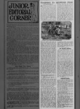
 TRAMPING TO REDWOOD PEAK Sat, Jan 8, 1910 – Page 2 · The San Francisco Call (San Francisco, California) · Newspapers.com
[This article was on a page of the San Francisco Call meant for kids, called Junior Section, thus the language seeming to be targeted toward young people. Harold French wrote this when he was 16. He was born in 1894. Harold was a critical figure in the history of Bay Area trails, nature, hiking and conservancy. He founded the Contra Costa Hills Club ten years after this article was published, which was instrumental in the conservation of the redwoods in Oakland. (See Oakland Sequoia Mountain Park; Part 1, the Bond Measure.) He was the namesake for the French trail, in Reinhardt Redwood Regional Park. Joaquin Miller was a famous poet, a self-promoting celebrity of the sort very common now. He bought a bare piece of hill land that he cultivated into a forest which is now Joaquin Miller Park. There are more articles by Harold French on this blog, and more to come. He didn't ride a bike, but he made an impact on my life, it so happens. - MF]
TRAMPING TO REDWOOD PEAK
BY HAROLD FRENCH
ALTHOUGH the holidays are gone and 1910 has begun with its study and work, the juniors may still look forward to their weekend walks as a sort of vacation on the installment plan. During your days off many of you have taken some Saturday trips that had been previously missed, and those who made haste to hike while the sun shone were rewarded with rare views from the ridges whitened with snow and frost. At sundown last Sunday evening as I climbed out of Canyon Toyon [I'm guessing, with that link to Toyon Trail. - MF] carrying a huge pack of red berries, I saw the afterglow burning on the snowfields of Mount Diablo, while the slope of Baldy remained sheeted with ice. ['Vollmer Peak was named in honor of the first police chief of the City of Berkeley, August Vollmer. It was formerly known as "Bald Peak".' from the Berkeley Hills wikipedia page - MF] |
| JOAQUIN MILLER PLANTING A TREE |
But "spring is coming," wild currant leaves are budding and in a fortnight their fragrant, pink bloom will enliven the canyons where already the pussy willow unfolds its furry fuzzy catkins. Fine physical exercise as walking is, its charm increases with compound interest as one acquires more knowledge of nature's open books, bound on one side by rock ribs and above by blue sky and floating clouds.
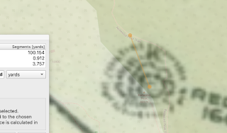
I have to talk about the places mentioned in this article. This 1912 Map Of Oakland And Vicinity by the Realty Union is an ideal companion to this 1910 article. It shows the Oakland Pier that the visitor might have reached by ferry to take the horseshoe train (Best I can tell, it means a local train that services a community, often running in a u-shape.) to Fruitvale Avenue, then left, uphill after a transfer, to Dimond. Here is my take on the journey French describes:
Here are some postcards showing the ferry to the Oakland Pier, the Pier terminals, the train traveling from the Pier to the city of Oakland, a ferry ticket and some Dimond Line (Fruitvale Avenue) transfer tickets. I found all these images on ebay.


After deboarding the train at Dimond Post Office, "Turn to the right up a steep hill for a block, then to your left up a road lined with eucalyptus and acacia trees. This long lane has its turning a mile up, where it twists around the foothills for half a mile farther, winding past weeping willows to a group of cottages." He is describing going Fruitvale > Macarthur > Lincoln, then all the way up Lincoln Avenue. Fascinating that he mentions it being lined with eucalyptus and acacia. You don't see them so much on Lincoln Avenue now, which is all built up, but closer to my neighborhood, at the foot of Joaquin Miller road, all the trees are acacia / eucalyptus, and in my neighborhood (Butters Canyon area) that's true to an extent, as well, as well as all around the Abbey, Joaquin Miller's former home. Redwoods, bays and oaks predominate further up the hill from the Abbey, and in the next drainages east. The group of cottages may have been some of his friends and neighbors, to whom he deeded some small subplots of his property, which still have the same long, distinctive shape as when he carved them out. Some were helpers, friends, artists. These are the properties uphill from the Woodminster market, on the north side. When Miller bought the property in 1886 it was bare. By 1910 it would have young trees growing on it. Now they are thick, especially near the Abbey, and below it.
When he talks about being at "The Hights," at 800' above the bay, he's talking about Joaquin Miller's Abbey. "Continue up the road nearly 300 more..." brings you to what is now Sanborn Drive and the meadow, through which Sunset trail runs. The eastern wall of the meadow is no longer "bristling with young trees," the mature native and non-native trees are now 110 years older, and quiet tall. The meadow does appear to have been planted, so I can imagine what he was seeing in 1910. Who knows what the trails looked like then. I wish I did! Here I take a guess that the "... trail winds directly up to the summit of Redwood peak, nearly a mile distant" describes something like the Fern Ravine trail, which is the main way up the drainage from Sunset trail. It is lined with ferns, heck the name is Fern Trail.

"A new forest of pines and cypress planted by the Realty Syndicate is growing rapidly along the ridge to the northward." sounds like he's talking about what's now the West Ridge trail. Realty Syndicate was the development firm of Frank C. Havens and F. M. "Borax" Smith. They owned and developed much of the Oakland hills. My home is on land that their company developed and sold. The area that later became Sequoia Park, and later Joaquin Miller Park was once known as "Smith's Reserve." A signature of this firm's development, in my personal opinion, was planting fast-growing trees along a road, then developing that road. You can see the stumps of Monterey Pines and Monterey Cypresses along the Castle Park Trail, parts of which were the "private road" in the 1912 map, before Skyline Boulevard was created. And you can still see this style of planting on the West Ridge trail (road) in Redwood Park:

"At an elevation of 1,600 feet you will come to a road that leads into the private grounds of John Classen." Click that link. He owned property to the northwest of Redwood Peak.


Continuing to Redwood Peak, "Here you reach a point 1,608 feet high, according to the topographic sheet of the United States geological survey. A mass of weathered sandstone boulders marks the crest, but the forest masks the view."


"A fine lunching and resting place lies a hundred yards down the northern slope, from which you may look down into the densely forested Redwood canyon, which, with the waters of Moraga valley, drains into San Leandro creek and Lake Chabot." That would probably be one of the flatter spots, off Redwood Peak Trail.
"To the eastward roll the hills of Contra Costa County, Rocky Ridge and Las Trampas, 1,900 feet high, and beyond them the San Ramon Valley, with Diablo looming double the height of the midway ranges. Northwesterly, six miles in an airline, lie Grizzly peak and Baldy, but double the distance if you follow the ridge." I've recently ridden my bike to Rocky Ridge and Las Trampas, so this article was very interesting to me, and you can see Rocky Ridge from Redwood Peak, if you know where to look through the young redwood trees that mostly block the view from the Peak. In 1910, the view was probably magnificent, as the redwoods had been completely logged to bare earth within the last sixty years, at that time. Fires took care of the rest. It's a different view, now. Grizzly Peak still bears that name, but Baldy is now Vollmer Peak, the bigger, but less visible neighbor to Grizzly.
"Your prettiest homeward route lies along the winding road through the forest from Classen's down to either Fruitvale or Leona heights. Later the latter will be a trip of special interest, because of its mines and minerals, woods, waterfalls and wild flowers."
Lots, here. I'll link to some other blog posts, instead of blathering on myself:
Unfrequented Bicycle Roads in the Vicinity of San Francisco - The San Francisco Call, 18 Apr 1897, Sun, Page 28
THE GLORY OF THE HILLS. - Hike to Redwood Peak - Alameda Daily Argus, 03 Sep 1904, Sat, Page 3
JOY TRIPS ARE MANY; BEAUTY-SPOTS PLENTY - Oakland Tribune - 28 Feb 1915, Sun - Page 8
The Hiker's Paradise by Louis Allen - Oakland Tribune 07 May 1922, Sun Page 77
On the Tip of the Cresent, by Louis Allen, Oakland Tribune, 24 Sep 1922, Sun, Page 64
Short Hikes for Sunday - Oakland Tribune 26 Aug 1923, Sun
FRUITVALE TO JOAQUIN MILLER'S
Juniors and grownups, too, from San Francisco, can take the Horseshoe train from Oakland pier to Fruitvale station, from which they should continue two miles up the beautiful avenue to Dimond postoffice, to which the Alameda county contingent can transfer. Turn to the right up a steep hill for a block, then to your left up a road lined with eucalyptus and acacia trees. This long lane has its turning a mile up, where it twists around the foothills for half a mile farther, winding past weeping willows to a group of cottages. You are now "On the Hights" (as spelt by the poets) and are fronting the estate of Joaquin Miller, "The Poet of the Sierras." A hundred thousand young trees planted by his hands are springing sturdily up the rocky slopes, each a living monument to the genius of Cincinnatus Heine Miller. This was the name Joaquin's parents gave him nearly 70 summers ago. Before gold was discovered in California he crossed the plains to Oregon with an emigrant train, and at the age of 14 tramped across the Siskiyou mountains and was adopted by the kindly Shasta Indians. Twenty years later he told the tale of their unhappy fate in his "Songs of the Sierras," under the title "The Last Taschastas," which begins with these, simple but haunting lines:
"The hills were brown, the heavens were blue,
A woodpecker pounded a pinetop shell,
While a partridge whistled the whole day through
For a rabbit to dance in the chaparral,
And a gray goose drumm’d, "All's well, all's well."

Here in one of his cottages, called "the Temple," he often lies until afternoon, clad in his fur robes and thinking out the themes he sets to verse. Perchance you may see him strolling about his pine plantation, and if so do not hesitate to pay your respects to this "good gray poet," whom you will find a lover of out of doors boys and girls as well as his fellow man.
UPWARD TO REDWOOD PEAK
At the entrance to "The Hights" you were 800 feet above the bay. Continue up the road nearly 300 more when you will arrive at a saddle and a stile. Turn in through this fence to a little meadow whose eastern wall is bristling with young pines. Up this flank a trail winds directly up to the summit of Redwood peak, nearly a mile distant. You are now on the headwaters of Dimond canyon, down through which a trip will be more enjoyable a month or two hence. As you ascend the course of a steep little stream you will see beautiful Woodwardia ferns down in a dell, while glossy huckleberry leaves brighten the shadows of the redwoods. Up you climb through the second growth of sequoias which hide the stumps of the giant trees that fell 60 years ago. A new forest of pines and cypress planted by the Realty Syndicate is growing rapidly along the ridge to the northward. At an elevation of 1,600 feet you will come to a road that leads into the private grounds of John Classen. He is a keen nature lover and welcomes others who wish to go up his rustic wood and rock built trail to the summit of Redwood peak. Here you reach a point 1,608 feet high, according to the topographic sheet of the United States geological survey. A mass of weathered sandstone boulders marks the crest, but the forest masks the view. A fine lunching and resting place lies a hundred yards down the northern slope, from which you may look down into the densely forested Redwood canyon, which, with the waters of Moraga valley, drains into San Leandro creek and Lake Chabot. To the eastward roll the hills of Contra Costa County, Rocky Ridge and Las Trampas, 1,900 feet high, and beyond them the San Ramon Valley, with Diablo looming double the height of the midway ranges. Northwesterly, six miles in an airline, lie Grizzly peak and Baldy, but double the distance if you follow the ridge. Your prettiest homeward route lies along the winding road through the forest from Classen's down to either Fruitvale or Leona heights. Later the latter will be a trip of special interest, because of its mines and minerals, woods, waterfalls and wild flowers.
I have to talk about the places mentioned in this article. This 1912 Map Of Oakland And Vicinity by the Realty Union is an ideal companion to this 1910 article. It shows the Oakland Pier that the visitor might have reached by ferry to take the horseshoe train (Best I can tell, it means a local train that services a community, often running in a u-shape.) to Fruitvale Avenue, then left, uphill after a transfer, to Dimond. Here is my take on the journey French describes:
 |
| The red line is my uneducated guess at what Harold French describes. If you want to zoom in and see stuff, visit this 300dpi version. |


After deboarding the train at Dimond Post Office, "Turn to the right up a steep hill for a block, then to your left up a road lined with eucalyptus and acacia trees. This long lane has its turning a mile up, where it twists around the foothills for half a mile farther, winding past weeping willows to a group of cottages." He is describing going Fruitvale > Macarthur > Lincoln, then all the way up Lincoln Avenue. Fascinating that he mentions it being lined with eucalyptus and acacia. You don't see them so much on Lincoln Avenue now, which is all built up, but closer to my neighborhood, at the foot of Joaquin Miller road, all the trees are acacia / eucalyptus, and in my neighborhood (Butters Canyon area) that's true to an extent, as well, as well as all around the Abbey, Joaquin Miller's former home. Redwoods, bays and oaks predominate further up the hill from the Abbey, and in the next drainages east. The group of cottages may have been some of his friends and neighbors, to whom he deeded some small subplots of his property, which still have the same long, distinctive shape as when he carved them out. Some were helpers, friends, artists. These are the properties uphill from the Woodminster market, on the north side. When Miller bought the property in 1886 it was bare. By 1910 it would have young trees growing on it. Now they are thick, especially near the Abbey, and below it.
When he talks about being at "The Hights," at 800' above the bay, he's talking about Joaquin Miller's Abbey. "Continue up the road nearly 300 more..." brings you to what is now Sanborn Drive and the meadow, through which Sunset trail runs. The eastern wall of the meadow is no longer "bristling with young trees," the mature native and non-native trees are now 110 years older, and quiet tall. The meadow does appear to have been planted, so I can imagine what he was seeing in 1910. Who knows what the trails looked like then. I wish I did! Here I take a guess that the "... trail winds directly up to the summit of Redwood peak, nearly a mile distant" describes something like the Fern Ravine trail, which is the main way up the drainage from Sunset trail. It is lined with ferns, heck the name is Fern Trail.

"A new forest of pines and cypress planted by the Realty Syndicate is growing rapidly along the ridge to the northward." sounds like he's talking about what's now the West Ridge trail. Realty Syndicate was the development firm of Frank C. Havens and F. M. "Borax" Smith. They owned and developed much of the Oakland hills. My home is on land that their company developed and sold. The area that later became Sequoia Park, and later Joaquin Miller Park was once known as "Smith's Reserve." A signature of this firm's development, in my personal opinion, was planting fast-growing trees along a road, then developing that road. You can see the stumps of Monterey Pines and Monterey Cypresses along the Castle Park Trail, parts of which were the "private road" in the 1912 map, before Skyline Boulevard was created. And you can still see this style of planting on the West Ridge trail (road) in Redwood Park:

"At an elevation of 1,600 feet you will come to a road that leads into the private grounds of John Classen." Click that link. He owned property to the northwest of Redwood Peak.


Continuing to Redwood Peak, "Here you reach a point 1,608 feet high, according to the topographic sheet of the United States geological survey. A mass of weathered sandstone boulders marks the crest, but the forest masks the view."


"A fine lunching and resting place lies a hundred yards down the northern slope, from which you may look down into the densely forested Redwood canyon, which, with the waters of Moraga valley, drains into San Leandro creek and Lake Chabot." That would probably be one of the flatter spots, off Redwood Peak Trail.

"Your prettiest homeward route lies along the winding road through the forest from Classen's down to either Fruitvale or Leona heights. Later the latter will be a trip of special interest, because of its mines and minerals, woods, waterfalls and wild flowers."
Lots, here. I'll link to some other blog posts, instead of blathering on myself:
Unfrequented Bicycle Roads in the Vicinity of San Francisco - The San Francisco Call, 18 Apr 1897, Sun, Page 28
THE GLORY OF THE HILLS. - Hike to Redwood Peak - Alameda Daily Argus, 03 Sep 1904, Sat, Page 3
JOY TRIPS ARE MANY; BEAUTY-SPOTS PLENTY - Oakland Tribune - 28 Feb 1915, Sun - Page 8
The Hiker's Paradise by Louis Allen - Oakland Tribune 07 May 1922, Sun Page 77
On the Tip of the Cresent, by Louis Allen, Oakland Tribune, 24 Sep 1922, Sun, Page 64
Short Hikes for Sunday - Oakland Tribune 26 Aug 1923, Sun
Comments
Post a Comment